Payhembury
| Payhembury | |
|---|---|
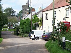 Village of Payhembury | |
 Payhembury Location within Devon | |
| Population | 682 (2011) |
| Civil parish |
|
| District | |
| Shire county | |
| Region | |
| Country | England |
| Sovereign state | United Kingdom |
| Post town | Honiton |
| Postcode district | EX14 |
| Police | Devon and Cornwall |
| Fire | Devon and Somerset |
| Ambulance | South Western |
| UK Parliament | |

Payhembury is a village and civil parish in the East Devon district of Devon, England.
The village is about six miles west of Honiton. At the time of the 2011 the parish had a population of 682,[1] and it is surrounded clockwise from the north by the parishes of Broadhembury, Awliscombe, Buckerell, Feniton, Talaton, Clyst Hydon and Plymtree.[2] The parish includes the hamlets of Colestocks, Lower Cheriton, Tale, and Upton.[3]
The parish church is dedicated to St. Mary and was mostly built in the fifteenth century. It includes a stone arcade made of Beer Stone which has several shields including the arms of the Courtenay family, a coloured roof and altar rails from the reign of Queen Anne.[4]
References[]
- ^ "Key Figures for 2011 Census: Payhembury (Parish)". www.neighbourhood.statistics.gov.uk. Office for national Statistics. Retrieved 20 November 2016.
- ^ "Map of Devon Parishes" (PDF). Devon County Council. Archived from the original (PDF) on 2 November 2013. Retrieved 20 November 2016.
- ^ "Payhembury Parish Boundary" (PDF). East Devon District Council. Retrieved 18 January 2017.
- ^ "Payhembury". Devon County Council. Retrieved 20 November 2016.
External links[]
 Media related to Payhembury at Wikimedia Commons
- Official Village Website
- Payhembury in the Domesday Book

This Devon location article is a stub. You can help Wikipedia by . |
- Villages in Devon
- Devon geography stubs