Pendé River
| Pendé River | |
|---|---|
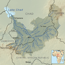 Map showing the Pendé River (Center left) within the Chari River drainage basin | |
| Native name | Rivière Pendé (French) |
| Location | |
| Countries | |
| Physical characteristics | |
| Source | |
| • location | Central African Republic |
| Mouth | |
• location | Logone River at Kim, Chad |
• coordinates | 9°5′20″N 16°27′55″E / 9.08889°N 16.46528°ECoordinates: 9°5′20″N 16°27′55″E / 9.08889°N 16.46528°E |
• elevation | 375 m (1,230 ft) |
| Basin size | 15,325 km2 (5,917 sq mi) |
| Discharge | |
| • average | 128 m3/s (4,500 cu ft/s) |

The Pendé River (French: Rivière Pendé) is a river in central Africa. It arises in Ouham-Pendé in the Central African Republic and flows north, forming a short part of the international boundary between the Central African Republic and Chad. It eventually merges with the Logone River near .
Historically it gave its name to the French administrative district Pendé, which was ceded to Germany as part of Neukamerun at the treaty of Fez 1912.
Hydrometry[]
The flow of the river observed over 28 years (1947–75) in Doba a town in Chad about 70 km above the mouth into the Logon.[1] The at Doba observed average annual flow during this period was 128 m³ / s fed by an area of about 14.300 km ² a majority of the total catchment area of the River.
The average monthly flow of the river Pendé hydrological station of Doba (in m³ / s )
(Calculated using the data for a period of 28 years, 1947–75)

References[]
- Rivers of the Central African Republic
- Rivers of Chad
- International rivers of Africa
- Central African Republic–Chad border
- Border rivers