Petare
Coordinates: 10°29′N 66°49′W / 10.483°N 66.817°W

Dulce Nombre de Jesús de Petare | |
|---|---|
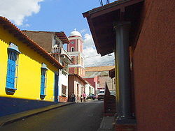 Historic center of Petare | |
 Flag | |
 Dulce Nombre de Jesús de Petare | |
| Coordinates: 10°29′N 66°49′W / 10.483°N 66.817°W | |
| Country | Venezuela |
| State | Miranda |
| Founded | February 17, 1621 |
| Government | |
| • Mayor | Carlos Ocariz |
| • Political party | Justice First |
| Elevation | 900 m (3,000 ft) |
| Population (2006) | |
| • Total | 369,000 |
| Demonym(s) | petareno(a) |
| Time zone | UTC−4 (VET) |
| Postal code | 1073 |
| Website | alcaldiamunicipiosucre.gov.ve |

Petare is a neighborhood in Miranda, Venezuela, and is part of the Metropolitan District of Caracas. It is located in the Sucre Municipality, one of the five divisions of Caracas. The city was founded in 1621 under the name of San Jose de Guanarito. It grew to become a part of the greater Caracas area as the latter expanded in area and population.
The neighborhood is towards the eastern edge of Caracas, but has developed its own commercial core. Two universities are located in Petare: Universidad Santa María and Universidad Metropolitana. Poverty remains a major limitation to the city's development. The population of Petare is 369,000.[1] It is regarded as one of the largest slums in the world.[2]
Petare station of the Caracas Metro is located in Petare.
References[]
- ^ City Population website, available online at [1], accessed on August 24, 2006
- ^ "Venezuela parliament rejects Russian 'interventionist communique'". UPI. January 27, 2017. Retrieved February 3, 2017.
External links[]
| Wikimedia Commons has media related to Petare. |
| show Authority control |
|---|
- Populated places in Miranda (state)
- Populated places established in 1621
- 1621 establishments in the Spanish Empire