Phahonyothin Road
 | |
|---|---|
| ทางหลวงแผ่นดินหมายเลข 1 | |
| ถนนพหลโยธิน Thanon Phahon Yothin | |
 | |
| Route information | |
| Part of | |
| Length | 1,005 km (624 mi) |
| Existed | 1936–present |
| Major junctions | |
| South end | Bangkok, Victory Monument |
| North end | Mae Sai district, Chiang Rai, border to |
| Location | |
| Provinces | Pathum Thani, Ayutthaya, Saraburi, Lopburi, Nakhon Sawan, Chainat, Kamphaeng Phet, Tak, Lampang, Phayao |
| Highway system | |
| Highways in Thailand | |
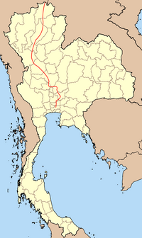
Phahonyothin Road (Thai: ถนนพหลโยธิน, RTGS: Thanon Phahon Yothin, pronounced [tʰā.nǒn pʰā.hǒn jōː.tʰīn]) or Highway 1 is a major road in Bangkok and one of the four primary highways in Thailand, which include Mittraphap Road (Highway 2), Sukhumvit Road (Highway 3), and Phet Kasem Road (Highway 4). It begins at Victory Monument in Bangkok and runs north to the Burmese border, with a total length of 1,005 km (624 mi).
History[]


Phahonyothin Road was originally called "Prachathipat Road" (Thai: ถนนประชาธิปัตย์, Thanon Prachathipat, literally "Democracy Road"), and reached just 22 km (14 mi) to Don Mueang. In 1938, Field Marshal Plaek Phibunsongkhram had the road extended from Don Mueang, through Bang Pa-In, Ayutthaya, Saraburi, Lopburi, and Singburi, making it 162 km (101 mi) long. The newly lengthened road was renamed Phahonyothin Road, in honor of General Phraya Phahol Pholphayuhasena (formerly Phot Phahonyothin), the second Prime Minister of Thailand and one of the heads of the 1932 revolution.[1]
Route[]
In Bangkok, Phahonyothin Road originates in Ratchathewi district and crosses Phaya Thai, Chatuchak, Bang Khen, Don Mueang, and Sai Mai districts before continuing into Pathum Thani Province, and on through Ayutthaya, Saraburi, Lopburi, Nakhon Sawan, Chainat, again through Nakhon Sawan, Kamphaeng Phet, Tak, Lampang, Phayao and finally Chiang Rai, ending in Mae Sai district, where it connects to Tachileik in Myanmar.
Phaholyothin Road in Bangkok is also a demarcation line between districts or sub-districts in several phases as follows:
- Thung Phaya Thai (left side) and Thanon Phaya Thai (right side) in Ratchathewi district, as a continuation of Phaya Thai Road, from Victory Monument to the bridge over the Khlong Samsen.
- Phaya Thai (left side) and Samsen Nai (right side) in Phaya Thai district throughout the entire area, from the bridge over the Khlong Samsen to the bridge over the Khlong Bang Sue (begins July 26, 2017).[2]
- Chatuchak (left side) and Chom Phon (right side) in Chatuchak district from the bridge over the Khlong Bang Sue to Ratchayothin Intersection.
- Lat Yao (left side) and Chan Kasem (right side) in Chatuchak district from Ratchayothin to Sena Nikhom Intersections.
- Lat Yao (left side) and Sena Nikhom (right side) in Chatuchak district from Sena Nikhom Intersection to Thong Chanya Bridge.
- Bang Khen district (left side) and Sai Mai district (right side) from the bridge over the Khlong Lam Phak Chi to Saphan Mai quarter.
- Don Mueang district (left side) and Sai Mai district (right side) from Saphan Mai quarter to the administrative boundary line between Bangkok and Pathum Thani.
See also[]
- Thai highway network
- Kunming-Bangkok Expressway
 Bangkok/Phahonyothin travel guide from Wikivoyage
Further reading[]
- Thomas fuller, "In Isolated Hills of Asia, New Roads to Speed Trade", New York Times, March 31, 2008
References[]
- ^ อรณี แน่นหนา, 2002. นามนี้มีที่มา. ประพันธ์สาส์น: กรุงเทพฯ.
Orani Naenna, 2002. Naam Ni Mi Thi Ma. Praphansarn: Bangkok. (Brief histories of 129 place names in Bangkok.) - ^ "ประกาศกรุงเทพมหานคร เรื่อง เปลี่ยนแปลงพื้นที่แขวงสามเสนใน และตั้งแขวงพญาไท เขตพญาไท" [Bangkok announcement subject: Changing the area of Samsen Nai Subdistrict and established Phaya Thai Subdistrict, Phaya Thai District] (PDF). Royal Thai Government Gazette (in Thai).
| Wikimedia Commons has media related to Thailand Route 1. |
Coordinates: 13°50′51″N 100°34′48″E / 13.8474°N 100.5800°E

Road infrastructure in Thailand | |||||||||
|---|---|---|---|---|---|---|---|---|---|
| Controlled-access highways |
| ||||||||
| Highways |
| ||||||||
- AH1
- National highways in Thailand
- Streets in Bangkok
- Ratchathewi District
- Phaya Thai District
- Chatuchak District
- Bang Khen District
- Don Mueang District
- Pathum Thani province
- Phra Nakhon Si Ayutthaya province
- Saraburi province
- Lopburi province
- Nakhon Sawan province
- Chai Nat province
- Kamphaeng Phet province
- Tak province
- Lampang province
- Phayao province
- Chiang Rai province