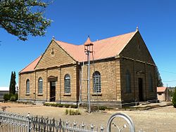
Philipstown, Northern Cape
Philipstown | |
|---|---|
 Reformed Church, Philipstown | |
 Philipstown | |
| Coordinates: 30°26′S 24°28′E / 30.433°S 24.467°ECoordinates: 30°26′S 24°28′E / 30.433°S 24.467°E | |
| Country | South Africa |
| Province | Northern Cape |
| District | Pixley ka Seme |
| Municipality | Renosterberg |
| Area | |
| • Total | 44.12 km2 (17.03 sq mi) |
| Population (2011)[1] | |
| • Total | 3,365 |
| • Density | 76/km2 (200/sq mi) |
| Racial makeup (2011) | |
| • Black African | 36.3% |
| • Coloured | 58.5% |
| • Indian/Asian | 0.4% |
| • White | 4.5% |
| • Other | 0.3% |
| First languages (2011) | |
| • Afrikaans | 70.2% |
| • Xhosa | 27.0% |
| • Other | 2.8% |
| Time zone | UTC+2 (SAST) |
| Postal code (street) | 8795 |
| PO box | 8795 |
Philipstown is a town in the eastern Karoo region of South Africa.
Town 56 km north-east of De Aar. It was established in May 1863 on the farm Rietfontein and became a municipality in August 1876. Named after Sir Philip Edmond Wodehouse (1811-1887), Governor of the Cape Colony from 1861 to 1870.[2]
At the jailhouse to the west of town is the building where a small force of the 65th Imperial Yeomanry and Native Police held off a large force of General De Wet's men during the Second Anglo-Boer War. During this action, Corporal William Sopp of the Imperial Yeomanry was awarded the Distinguished Conduct Medal for courage under fire when he rode out from this building to warn the approaching Australian Bushmen who were coming to relieve them that there were hundreds of Boers lying in wait for them. The Boers fired at this lone horseman as he raced to the Australians then raced back, arriving back at the jail without injury. This caused De Wet to delay his movements for several hours and turned him back towards a large pursuing British column.[citation needed]
References[]
- ^ Jump up to: a b c d "Main Place Philipstown". Census 2011.
- ^ "Dictionary of Southern African Place Names (Public Domain)". Human Science Research Council. p. 364.
| Wikimedia Commons has media related to Philipstown, Northern Cape. |
- Populated places in the Renosterberg Local Municipality
- 1863 establishments in the Cape Colony
- Northern Cape geography stubs


