Pic de Sanfonts
| Pic de Sanfonts | |
|---|---|
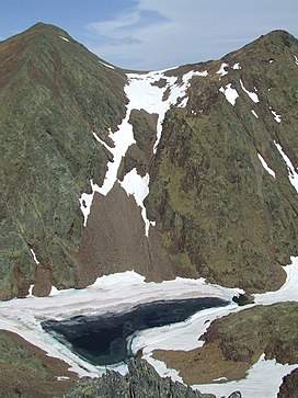 Pic de Sanfonts (left), Agulla de Baiau (right) and Estany Negre. | |
| Highest point | |
| Elevation | 2,894 m (9,495 ft) |
| Prominence | 150 m (490 ft) |
| Isolation | 1.18 km (0.73 mi) to Coma Pedrosa |
| Coordinates | 42°36′0″N 1°26′43″E / 42.60000°N 1.44528°ECoordinates: 42°36′0″N 1°26′43″E / 42.60000°N 1.44528°E |
| Geography | |
 Pic de Sanfonts Location in the Pyrenees | |
| Location | Andorra |
| Parent range | Pyrenees |

Pic de Sanfonts (Catalan pronunciation: [ˈpiɡ də səmˈfɔns]) is a mountain in the Pyrenees on the border of Spain and northwest Andorra. The nearest town is Arinsal, La Massana.[1] It is a subpeak of, and 1.2 km southwest of, Coma Pedrosa (2942 m), the highest mountain in Andorra.
References[]
- ^ Parroquia de la Massana, Comú de la Massana Archived 2013-12-14 at the Wayback Machine. (in Catalan)
This Andorran location article is a stub. You can help Wikipedia by . |
This article about a location in Catalonia is a stub. You can help Wikipedia by . |
Categories:
- Mountains of Andorra
- Mountains of Catalonia
- Mountains of the Pyrenees
- Andorra–Spain border
- International mountains of Europe
- Two-thousanders of Andorra
- Two-thousanders of Spain
- Andorra geography stubs
- Catalonia geography stubs