Pica d'Estats
| Pica d'Estats | |
|---|---|
| Pic d'Estats | |
 | |
| Highest point | |
| Elevation | 3,143 m (10,312 ft) |
| Prominence | 1,277 m (4,190 ft) |
| Coordinates | 42°40′02″N 01°23′50″E / 42.66722°N 1.39722°ECoordinates: 42°40′02″N 01°23′50″E / 42.66722°N 1.39722°E |
| Geography | |
 Pica d'Estats Pyrenees | |
| Location | Pallars Sobirà, Spain Ariège, France |
| Parent range | Pyrenees |
| Climbing | |
| First ascent | 1864 by Henry Russell and Jean-Jacques Denjean |

Pica d'Estats (or The States Peak) (Catalan: Pica d'Estats, French: Pic d'Estats) is a 3,143-metre-high (10,312 ft) mountain in the Montcalm Massif, Pyrenees.[1] on the Spanish–French border, and is the highest mountain in Catalonia.
This mountain is included in the Parc Natural de l'Alt Pirineu.

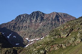
Pica d'Estats, SW face in August 2005
Summits[]
The summit is located between the Catalan municipality of Alins in Pallars Sobirà and the French district of Ariège. It comprises three peaks, all lying close to each other:
- Central peak (3,143 m)[2]
- Western peak, or Pic de Verdaguer, (3,131 m)
- Eastern peak, or Punta Gabarró, (3,115 m)
This eastern peak is the geodesic vertex. The ridge runs north-northwest to southeast along the Spanish–French border.
See also[]
References[]
- ^ "Mapa Topogràfic de Catalunya". Institut Cartogràfic de Catalunya. Retrieved May 25, 2012..
- ^ "Track and description"..
Categories:
- Pyrenean three-thousanders
- France–Spain border
- International mountains of Europe