Pinecreek–Piney Border Crossing
| Pinecreek–Piney Border Crossing | |
|---|---|
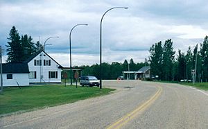
 Pinecreek–Piney Border Crossing as seen in 1998 | |
| Location | |
| Country | United States; Canada |
| Location |
|
| Coordinates | 49°00′00″N 95°58′41″W / 49°N 95.978172°WCoordinates: 49°00′00″N 95°58′41″W / 49°N 95.978172°W |
| Details | |
| Opened | 1922 |
| US Phone | (218) 463-1952 |
| Canadian Phone | (204) 423-2153 |
| Hours | Open 9:00 am–5:00 pm |
| Website https://www.cbp.gov/contact/ports/pinecreek | |
The Pinecreek–Piney Border Crossing connects the communities of Pinecreek, Minnesota and Piney, Manitoba on the Canada–U.S. border. It is connected by Minnesota State Highway 89 in Roseau County on the American side and Manitoba Highway 89 in the Rural Municipality of Piney on the Canadian side.
Although operated by the Minnesota Department of Transportation, the adjacent Piney Pinecreek Border Airport's runway crosses the international border.[1] There is an access drive to the airport on each side of the border. Small aircraft can land at this airport from either country, be inspected by officers from the other country and if admitted, continue to fly into the other country. Some pilots not crossing the border have reported unpleasant experiences at this airport.[2]
The crossing is the least busy in Minnesota, with an average of fewer than 25 cars a day.[1] The Canadian border station at Piney was built in 1953. The U.S. replaced its brick border station, which was built in 1958, in 2013.
See also[]
References[]
- ^ a b "Chapter 5: The 49th Parallel". United Divide: A Linear Portrait of the USA/Canada Border. The Center for Land Use Interpretation. Winter 2015.
- ^ Collins, Bob (August 31, 2016). "In Minnesota, an airport runway spans two countries". Minnesota Public Radio. Retrieved 22 December 2016.
- Canada–United States border crossings
- 1922 establishments in Manitoba
- 1922 establishments in Minnesota
- Buildings and structures in Roseau County, Minnesota
