Ping River
| Ping River | |
|---|---|
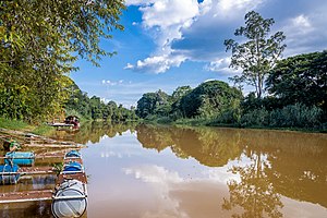 Ping River at Chiang Mai in October 2020. | |
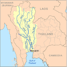 Map of the Chao Phraya River drainage basin showing the Ping River | |
| Location | |
| Country | Thailand |
| District | Chiang Mai, Lamphun, Tak, Kamphaeng Phet, Nakhon Sawan |
| Cities | Chiang Mai, Saraphi, San Sai, Kamphaeng Phet, Banphot Phisai |
| Physical characteristics | |
| Source | Khun Ping[1] |
| • location | Doi Thuai, Chiang Dao, Chiang Mai Province |
| • coordinates | 19°48′45″N 98°50′20″E / 19.81250°N 98.83889°E |
| • elevation | 1,700 m (5,600 ft) |
| Mouth | Chao Phraya River, Pak Nam Pho |
• location | Nakhon Sawan province |
• elevation | 25 m (82 ft) |
| Length | 658 km (409 mi) |
| Basin size | 44,688 km2 (17,254 sq mi) |
| Discharge | |
| • location | Nakhon Sawan |
| • average | 265 m3/s (9,400 cu ft/s) |
| • maximum | 2,302 m3/s (81,300 cu ft/s) |
| Basin features | |
| Tributaries | |
| • left | , , Li River, Wang River |
| • right | Taeng River, |

The Ping River (Thai: แม่น้ำปิง, RTGS: Maenam Ping, pronounced [mɛ̂ː.náːm pīŋ]), along with the Nan River, is one of the two main tributaries of the Chao Phraya River.[2] It originates at in the Daen Lao Range, in Chiang Dao district, Chiang Mai Province. After passing Chiang Mai, it flows through the provinces of Lamphun, Tak, and Kamphaeng Phet. At the confluence with the Nan River at Nakhon Sawan (also named Paknam Pho in Thai), it forms the Chao Phraya River.
Tributaries[]
- (Joins the Ping at 16°29′42″N 99°29′56″E / 16.49500°N 99.49889°E)
- (Joins the Ping at 16°41′02″N 99°16′16″E / 16.68389°N 99.27111°E)
- (Joins the Ping at 16°44′46″N 99°13′05″E / 16.74611°N 99.21806°E)
- (Placement in tributary tree is approximate, geographical coordinates unavailable due to poor satellite resolution)
- Wang River (Joins the Ping at 17°07′25″N 99°03′35″E / 17.12361°N 99.05972°E in the town of Tak)
- Tributaries include , , & Rivers
- (Joins the Ping at 17°02′18″N 99°04′00″E / 17.03833°N 99.06667°E)
- (Joins the Ping at 17°41′17″N 98°45′01″E / 17.68806°N 98.75028°E)
- (Placement in tributary tree is approximate, geographical coordinates unavailable due to poor satellite resolution)
- (Joins the Ping at 18°11′19″N 98°38′02″E / 18.18861°N 98.63389°E)
- (Joins the Ping at 18°22′12″N 98°40′55″E / 18.37000°N 98.68194°E)
- Li River (Joins the Ping at 18°25′43″N 98°42′08″E / 18.42861°N 98.70222°E)
- (Placement in tributary tree is approximate, geographical coordinates unavailable due to poor satellite resolution)
- (Joins the Ping at 18°30′05″N 98°51′04″E / 18.50139°N 98.85111°E)
- (Joins the Khan at 18°32′58″N 98°51′37″E / 18.54944°N 98.86028°E)
- (Joins the Ping at 18°32′33″N 98°56′07″E / 18.54250°N 98.93528°E)
- (Joins Kuang at 18°32′23″N 98°56′29″E / 18.53972°N 98.94139°E)
- (Placement in tributary tree is approximate, geographical coordinates unavailable due to inaccurate station data from Royal Irrigation Department)
- (Joins Kuang at 18°32′23″N 98°56′29″E / 18.53972°N 98.94139°E)
- (Placement in tributary tree is approximate, geographical coordinates unavailable due to poor satellite resolution)
- (Placement in tributary tree is approximate, geographical coordinates presently undeterminable due to recently built dam)
- (Placement in tributary tree is approximate, geographical coordinates presently undeterminable due to recently built dam)
- (Placement in tributary tree is approximate, geographical coordinates unavailable due to poor satellite resolution)
- (Placement in tributary tree is approximate, geographical coordinates unavailable due to poor satellite resolution)
- (Placement in tributary tree is approximate, geographical coordinates unavailable due to poor satellite resolution)
- (Joins the Ping at 18°53′28″N 98°58′22″E / 18.89111°N 98.97278°E)
- (Joins the Ping at 18°55′13″N 98°58′02″E / 18.92028°N 98.96722°E)
- Nai River (Placement in tributary tree is approximate, geographical coordinates unavailable due to poor satellite resolution)
- Taeng River (Joins the Ping at 19°06′08″N 98°56′49″E / 19.10222°N 98.94694°E)
- (Joins the Ping at 19°09′11″N 99°00′44″E / 19.15306°N 99.01222°E)
Ping Basin[]
The Ping Basin is one of the largest drainage basins of the Chao Phraya Watershed, draining 33,896 square kilometres (13,087 sq mi) of land.
The greater Ping Basin, i.e. the basin of the entire Ping river system including its tributary the Wang River, drains a total of 44,688 square kilometres (17,254 sq mi).
The main dams in the basin are the Bhumibol Dam and the .
National Parks[]
The Ping itself originates in Huai Nam Dang National Park and flows through Mae Ping National Park.
Gallery[]

Bathing elephants in the Taeng River, a Ping tributary
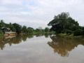
Ping River, northern outskirts of Chiang Mai

A Ping tributary, the Chaem River flows through the town of Mae Chaem
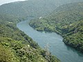
Ping River, upstream from the Bhumibol Dam
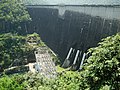
Bhumibol Dam, 154 metres (505 ft) long, creating a reservoir with a surface area of 300 square kilometres (120 sq mi).

Wang River, the main tributary of the Ping, flowing through Lampang

Confluence of the Ping with the Nan River at Nakhon Sawan


References[]
| Wikimedia Commons has media related to Ping River. |
- ^ "Chiang Dao National Park". Thai Forest Booking. Retrieved 2009-05-20.
- ^ "Mae Ping River: Lifeline of Chiangmai Province". Chiangmai and Chiangrai Magazine. 2008. Archived from the original on 2009-11-29. Retrieved 2009-04-02.
| Authority control |
|
|---|
- Rivers of Thailand
- Geography of Chiang Mai Province
- Geography of Lamphun Province
- Geography of Tak Province
- Geography of Kamphaeng Phet Province
- Chao Phraya River