Pinka
| Pinka | |
|---|---|
 | |
 | |
| Location | |
| Countries | Austria and Hungary |
| Physical characteristics | |
| Mouth | |
• location | Rába near Körmend |
• coordinates | 46°59′57″N 16°35′23″E / 46.9991°N 16.5897°ECoordinates: 46°59′57″N 16°35′23″E / 46.9991°N 16.5897°E |
| Length | 99.8 km (62.0 mi) [1] |
| Basin features | |
| Progression | Rába→ Danube→ Black Sea |

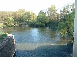
The Pinka (German pronunciation: [ˈpɪŋka] (![]() listen)) is a river in Central Europe with a length of approximately 100 km (60 mi). Its source is located in Styria, eastern Austria, next to the provincial border of Burgenland. It passes into Hungary between the villages of and Felsőcsatár, and crosses the Austrian-Hungarian border five times. Further it flows into the Rába river near Körmend. Its main tributary is the .
listen)) is a river in Central Europe with a length of approximately 100 km (60 mi). Its source is located in Styria, eastern Austria, next to the provincial border of Burgenland. It passes into Hungary between the villages of and Felsőcsatár, and crosses the Austrian-Hungarian border five times. Further it flows into the Rába river near Körmend. Its main tributary is the .
Important towns on its course are Pinkafeld (Hungarian: Pinkafő) and Oberwart (Hungarian: Felsőőr).
References[]
- ^ Digitaler Atlas der Steiermark (Styria)
| Authority control |
|
|---|
This Styria location article is a stub. You can help Wikipedia by . |
Categories:
- Tributaries of the Rába
- Rivers of Burgenland
- Rivers of Styria
- Rivers of Hungary
- Oberwart District
- Geography of Vas County
- Rivers of Austria
- International rivers of Europe
- Styria geography stubs
- Austria river stubs
- Europe river stubs
- Hungary geography stubs