Pinos Altos Historic District
Pinos Altos Historic District | |
 | |
| Location | Roughly bounded by Gold Ave. and Cherry, Main, Church, and Silver Sts., Pinos Altos, New Mexico |
|---|---|
| Coordinates | 32°51′58″N 108°13′09″W / 32.86611°N 108.21917°WCoordinates: 32°51′58″N 108°13′09″W / 32.86611°N 108.21917°W |
| Area | 72 hectares (180 acres) |
| Built | 1860 |
| NRHP reference No. | 84002945[1] |
| Added to NRHP | May 21, 1984 |

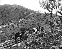
Pinos Altos Railroad
The Pinos Altos Historic District is a historic district which was listed on the National Register of Historic Places in 1984. It includes 37 contributing buildings on 72 hectares (180 acres).[1]
It is roughly bounded by Gold Ave. and Cherry, Main, Church, and Silver Streets.
It was a gold camp in the 1800s. It is located on the Continental Divide, at elevation 7,067 feet (2,154 m), in the . The first house there was built in 1860, had a dirt roof, and still survived in 1929.[2]
Two log buildings, both built of square hewn logs, are in the district:
- the Pinos Altos School, on Main Street, the first school in Pinos Altos, assertedly built in 1866
- the John McDonald cabin, on Spring Street, also probably built in the 1860s.[2]
References[]
- ^ a b "National Register Information System". National Register of Historic Places. National Park Service. November 2, 2013.
- ^ a b Susan Berry (August 1982). "National Register of Historic Places Inventory/Nomination: Pinos Altos Historic District". National Park Service. Retrieved July 28, 2019. With accompanying nine photos from 1982
| Topics | |
|---|---|
| Lists by state |
|
| Lists by insular areas | |
| Lists by associated state | |
| Other areas | |
| Related | |
| |
This article about a property in New Mexico on the National Register of Historic Places is a stub. You can help Wikipedia by . |
Categories:
- National Register of Historic Places in Grant County, New Mexico
- Historic districts on the National Register of Historic Places in New Mexico
- Buildings and structures completed in 1860
- New Mexico Registered Historic Place stubs