Pirikanoka

From Wikipedia, the free encyclopedia
Map all coordinates using: OpenStreetMap 
Download coordinates as: KML

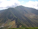
Pirikanoka (ピリカノカ) (lit. 'beautiful form') is the Ainu name, sung in yukar, for a grouping of geological features in Hokkaidō, Japan. In 2009 Pirikanoka was nationally designated a Place of Scenic Beauty, with the first six sites listed below, with an extension in 2012 to include the next three, and another in 2014 for the tenth. Each has its own name in Ainu.[1][2][3]

List of features[]

Name Municipality Comments Image Coordinates
Mount Kudo
九度山
Kudo-san or Kutōn-nupuri
Nayoro 44°25′08″N 142°31′46″E / 44.4190261°N 142.5295288°E / 44.4190261; 142.5295288 (Mount Kudo)
Mount Kogane
黄金山
Kogane-yama or Pinnetai-orushipe
Ishikari 43°37′26″N 141°28′23″E / 43.624°N 141.473167°E / 43.624; 141.473167 (Mount Kogane)
Cape Kamui
神威岬
Kamui-misaki or Kamui-etō
Esashi, Hamatonbetsu different from Cape Kamui 北見神威岬 神威岬公園 よりP6260503.jpg 45°03′35″N 142°30′14″E / 45.059606°N 142.503993°E / 45.059606; 142.503993 (Cape Kamui)
Cape Erimo
襟裳岬
Erimo-misaki or Onne-enrumu
Erimo Erimo misaki 01.JPG 41°55′28″N 143°14′57″E / 41.924444°N 143.249167°E / 41.924444; 143.249167 (Cape Erimo)
Ganbō Rock
瞰望岩
Ganbō-iwa or Enka-rushi
Engaru Engaru Hokkaido April 2004.jpg 44°03′16″N 143°31′02″E / 44.054441°N 143.517105°E / 44.054441; 143.517105 (Ganbō Rock)
Kamuichashi
カムイチャシ
Kamuichashi
Toyoura 42°34′43″N 140°36′56″E / 42.578639°N 140.615640°E / 42.578639; 140.615640 (Kamuichashi)
Etomo Peninsula Coastline
絵鞆半島外海岸
Etomo-hantō soto kaigan
Muroran Etomo Pen.JPG 42°19′22″N 140°57′46″E / 42.322778°N 140.962639°E / 42.322778; 140.962639 (Etomo Peninsula Coastline)
Mount Tokachiporoshiri
十勝幌尻岳
Tokachiporoshiri-dake or Tokachi-poroshiri
Obihiro, Nakasatsunai Mount Satsunai 2012-07-08.jpg 42°41′44″N 142°51′34″E / 42.695556°N 142.859444°E / 42.695556; 142.859444 (Mount Tokachiporoshiri)
Mount Poroshiri
九度山
Poroshiri-dake or Poroshiri
Biratori, Niikappu Mt.Poroshiridake from Mt.Tottabetsudake.jpg 42°43′10″N 142°40′58″E / 42.719444°N 142.682778°E / 42.719444; 142.682778 (Mount Poroshiri)
Okikurumi Chashi and Muinoka
オキクルミのチャシ及びムイノカ
Okikurumi no chashi oyobi Muinoka
Biratori 42°40′12″N 142°12′21″E / 42.669893°N 142.205774°E / 42.669893; 142.205774 (Okikurumi Chashi and Muinoka)

See also[]

References[]

  1. ^ ピリカノカ [Pirikanoka] (in Japanese). Agency for Cultural Affairs. Retrieved 16 February 2015.
  2. ^ ピリカノカ [Pirikanoka] (in Japanese). Agency for Cultural Affairs. Retrieved 16 February 2015.
  3. ^ 国の指定・選定文化財一覧 [List of National Cultural Properties] (in Japanese). Hokkaido Government Board of Education. Retrieved 16 February 2015.
Retrieved from ""