Piz Argient
| Piz Argient | |
|---|---|
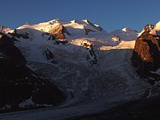 Bellavista (left and centre), Piz Argient (snowy dome, right) and Crast' Agüzza (rocky peak, extreme right) | |
| Highest point | |
| Elevation | 3,945 m (12,943 ft) |
| Prominence | 99 m (325 ft)[1] |
| Parent peak | Piz Zupò |
| Isolation | 0.5 km (0.31 mi) |
| Coordinates | 46°21′57.28″N 9°55′30.9″E / 46.3659111°N 9.925250°ECoordinates: 46°21′57.28″N 9°55′30.9″E / 46.3659111°N 9.925250°E |
| Naming | |
| English translation | Silver peak |
| Geography | |
 Piz Argient Location in the Alps | |
| Location | Italy / Switzerland |
| Parent range | Bernina Range |
| Geology | |
| Mountain type | Granite |
| Climbing | |
| First ascent | 1869 by Seiler and von Seldeneck, with guides Christian Grass, J. B. Walther and a chamois hunter |
| Easiest route | North-east ridge from the Fuorcla dal Zupò (F) |

Piz Argient (3,945 m) is a mountain in the Bernina Range of the Alps on the border between Italy and the Swiss canton of Graubünden.
The peak is bounded to the north by the Morteratsch Glacier, to the west by the Upper Scerscen Glacier, and to the south and east by the Fellaria Glacier. It is separated from Piz Zupò to its east by the Fuorcla dal Zupò (3,851 m) and from Crast' Agüzza to its north-west by the Fuorcla da l'Argient (3,705 m).
Huts[]
- Marco e Rosa Hut (3,610 m)
- Marinelli Hut (2,813 m)
References[]
- Collomb, Robin, Bernina Alps, Goring: West Col Productions, 1988
External links[]
This Italian location article is a stub. You can help Wikipedia by . |
This Graubünden location article is a stub. You can help Wikipedia by . |
Categories:
- Bernina Range
- Engadin
- Mountains of the Alps
- Alpine three-thousanders
- Mountains of Lombardy
- Italy–Switzerland border
- International mountains of Europe
- Mountains of Switzerland
- Mountains of Graubünden
- Three-thousanders of Switzerland
- Italy geography stubs
- Graubünden geography stubs