Piz Badus
| Piz Badus | |
|---|---|
| Six Madun | |
 | |
| Highest point | |
| Elevation | 2,928 m (9,606 ft) |
| Prominence | 529 m (1,736 ft)[1] |
| Parent peak | Piz Gannaretsch |
| Isolation | 4.35 km (2.70 mi) |
| Coordinates | 46°37′20″N 8°39′48″E / 46.62222°N 8.66333°ECoordinates: 46°37′20″N 8°39′48″E / 46.62222°N 8.66333°E |
| Geography | |
 Piz Badus Location in Switzerland | |
| Location | Uri/Graubünden, Switzerland |
| Parent range | Lepontine Alps |
| Climbing | |
| Easiest route | southeastern ridge from Val Maighels / Maighels hut |

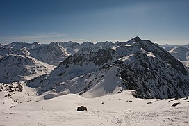
Piz Badus or Six Madun is a mountain in the Lepontine Alps, lying on the border between the cantons of Uri and Graubünden.
In its northwestern face, which is the Graubünden side, lies Tomasee, source of the Anterior Rhine. It is possible to reach the lake on a path from Oberalp Pass, suitable for most walkers although still a mountain trail.[2]
References[]
- ^ Swisstopo maps
- ^ (in English)Hike Switzerland to the source of the Rhine in Graubünden
External links[]
This Graubünden location article is a stub. You can help Wikipedia by . |
This Canton of Uri location article is a stub. You can help Wikipedia by . |
Categories:
- Mountains of the Alps
- Alpine three-thousanders
- Alpine Rhine basin
- Mountains of Graubünden
- Mountains of the canton of Uri
- Graubünden–Uri border
- Lepontine Alps
- Mountains of Switzerland
- Two-thousanders of Switzerland
- Graubünden geography stubs
- Canton of Uri geography stubs