Plana Cays
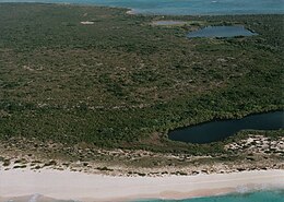 The western Plana Cay, looking northeast | |
 Plana Cays The location of Plana Cays within the Bahamas | |
| Geography | |
|---|---|
| Location | Atlantic Ocean |
| Coordinates | 22°36′00″N 73°34′23″W / 22.600°N 73.573°WCoordinates: 22°36′00″N 73°34′23″W / 22.600°N 73.573°W |
| Type | Cay |
| Archipelago | Lucayan Archipelago |
| Administration | |
Bahamas | |

The Plana Cays are a group of two small uninhabited islands in the southern Bahama Islands, located east of Acklins Island and west of Mayaguana Island.

Topographic map of Acklins Island and Crooked Island, with Plana Cays in the east (right).
The eastern cay was the last natural habitat of the Bahamian Hutia, a species of rabbit-sized rodent. It was thought to be extinct until 1966, when a population was found on the Plana Cays by biologist Garrett Clough. Hutias have since been transplanted from the Plana Cays to other parts of the Bahamas.[1]
The Plana Cays have been suggested as the first landfall of Christopher Columbus in the New World.[2][3][non-primary source needed]
References[]
- ^ "Hungry for hutia? Our taste for Bahamas' "most peaceable rodent" shaped its diversity". eurekalert.org (Press release). Gainesville, FL: Florida Museum of Natural History. 28 January 2020.
- ^ Pickering, Keith A. (August 1994). "Columbus's Plana landfall: Evidence for the Plana Cays as Columbus's 'San Salvador'" (PDF). DIO – the International Journal of Scientific History. 4 (1): 13–32. Retrieved 16 March 2009.
- ^ "Updated Columbus Landfall". columbuslandfall.com. Retrieved 31 May 2018.
- Atrill, Rod (2000). "The Southern Bahamas". www.bahamaswildlife.fsnet.co.uk. Retrieved 20 February 2005.
This Bahamian location article is a stub. You can help Wikipedia by . |
Categories:
- Uninhabited islands of the Bahamas
- Bahamas geography stubs