Podbiel
Podbiel | |
|---|---|
Village | |
 | |
 Coat of arms | |
 Podbiel Location of Podbiel in Slovakia | |
| Coordinates: 49°19′N 19°29′E / 49.317°N 19.483°ECoordinates: 49°19′N 19°29′E / 49.317°N 19.483°E | |
| Country | Slovakia |
| Region | Žilina |
| District | Tvrdošín |
| First mentioned | 1564 |
| Area | |
| • Total | 19.293 km2 (7.449 sq mi) |
| Elevation | 555 m (1,821 ft) |
| Population (2004-12-31) | |
| • Total | 1,258 |
| • Density | 65/km2 (170/sq mi) |
| Postal code | 027 42 |
| Car plate | TS |

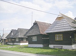
Podbiel is a village and municipality in Tvrdošín District in the Žilina Region of northern Slovakia. It contains a beautiful set of traditional wooden cottages, which have been declared a folk architecture preservation area.
History[]
In historical records, the village was first mentioned in 1564.
Geography[]
The municipality lies at an altitude of 555 metres and covers an area of 19.293 km2. It has a population of about 1255 people.
External links[]
| Authority control |
|
|---|
This Žilina Region geography article is a stub. You can help Wikipedia by . |
Categories:
- Villages and municipalities in Tvrdošín District
- Žilina Region geography stubs