Polanów
Polanów | |
|---|---|
 | |
 Coat of arms | |
 Polanów | |
| Coordinates: 54°6′N 16°42′E / 54.100°N 16.700°E | |
| Country | |
| Voivodeship | West Pomeranian |
| County | Koszalin |
| Gmina | Polanów |
| Town rights | 1313 |
| Government | |
| • Mayor | Grzegorz Paweł Lipski[1] |
| Area | |
| • Total | 7.61 km2 (2.94 sq mi) |
| Population (2017[1]) | |
| • Total | 2,949 |
| • Density | 390/km2 (1,000/sq mi) |
| Time zone | UTC+1 (CET) |
| • Summer (DST) | UTC+2 (CEST) |
| Postal code | 76-010 |
| Area code(s) | +48 94 |
| Vehicle registration | ZKO |
| Website | http://www.polanow.pl |

Polanów [pɔˈlanuf] (German: Pollnow) is a town in northern Poland, located in the Koszalin County of the West Pomeranian Voivodeship. It has 2,949 inhabitants (2017).
History[]
The settlement was first mentioned in 13th century, and was granted town rights in 1313[1] under Lübeck law.
The town was completely destroyed during World War II, in fires set by victorious Red Army soldiers.
Points of interest[]
- Gołogóra transmitter, a facility for FM-/TV-broadcasting with 2 guyed masts, which are 271 respectively 115 metres tall
- Historic churches: Church of the Assumption, Exaltation of the Holy Cross church
- Zalew Polanowski (artificial lake)
- Historical watermill complex

Church of the Assumption
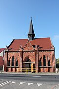
Exaltation of the Holy Cross church

Zalew Polanowski


Town twinning[]
Polanów is twinned with:[2]
 Gedern, Germany
- Rothenklempenow, Germany
Notable people[]
- Julius Leopold Pagel (1851–1912) a German physician and historian of medicine.
References[]
- ^ Jump up to: a b c "Polanów (zachodniopomorskie)". Polska w liczbach (in Polish). Retrieved 29 October 2019.
- ^ "Miasta partnerskie". Polanów.pl (in Polish). Retrieved 29 October 2019.
External links[]
| Wikimedia Commons has media related to Polanów. |
Coordinates: 54°06′N 16°42′E / 54.100°N 16.700°E

| show Authority control |
|---|
This West Pomeranian Voivodeship location article is a stub. You can help Wikipedia by . |
Categories:
- Cities and towns in West Pomeranian Voivodeship
- Koszalin County
- West Pomeranian geography stubs