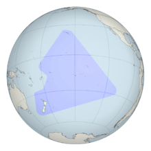
Polynesian navigation
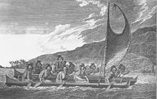
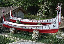
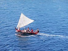
Polynesian navigation was used for thousands of years to enable long voyages across thousands of kilometres of the open Pacific Ocean. Polynesians made contact with nearly every island within the vast Polynesian Triangle, using outrigger canoes or double-hulled canoes. The double-hulled canoes were two large hulls, equal in length, and lashed side by side. The space between the paralleled canoes allowed for storage of food, hunting materials, and nets when embarking on long voyages.[1] Polynesian navigators used wayfinding techniques such as the navigation by the stars, and observations of birds, ocean swells, and wind patterns, and relied on a large body of knowledge from oral tradition.[2][3]
Navigators travelled to small inhabited islands using wayfinding techniques and knowledge passed by oral tradition from master to apprentice, often in the form of song. Generally, each island maintained a guild of navigators who had very high status; in times of famine or difficulty, they could trade for aid or evacuate people to neighbouring islands. As of 2014, these traditional navigation methods are still taught in the Polynesian outlier of Taumako in the Solomons and by voyaging societies throughout the Pacific.
Both wayfinding techniques and outrigger canoe construction methods have been kept as guild secrets, but in the modern revival of these skills, they are being recorded and published.
History[]
Between about 3000 and 1000 BC speakers of Austronesian languages spread through the islands of Southeast Asia – most likely starting out from Taiwan,[4] as tribes whose natives were thought to have previously arrived from mainland South China about 8000 years ago – into the edges of western Micronesia and on into Melanesia, through the Philippines and Indonesia. In the archeogenetic record, there are well-defined traces of this expansion that allow the path it took to be followed and dated with a degree of certainty.[5][6] In the mid-2nd millennium BC, a distinctive culture appeared suddenly in north-west Melanesia, in the Bismarck Archipelago, the chain of islands forming a great arch from New Britain to the Admiralty Islands.
This culture, known as Lapita, stands out in the Melanesian archeological record, with its large permanent villages on beach terraces along the coasts. Particularly characteristic of the Lapita culture is the making of pottery, including a great many vessels of varied shapes, some distinguished by fine patterns and motifs pressed into the clay. Between about 1300 and 900 BC, the Lapita culture spread 6000 km further to the east from the Bismarck Archipelago, until it reached as far as Tonga and Samoa.[7] Lapita pottery persisted in places such as Samoa, Tonga, and Fiji for many years after its introduction to Western Polynesia but eventually died out in most of Polynesia due to the scarcity of clay.[8] Although the production of ceramics did not travel beyond Western Polynesia, some ceramic materials have been recovered through archeological excavations in the Central Polynesia but have been attributed to trade.[9]
In accordance with Polynesian oral tradition, the geography of Polynesian navigation pathways is said to resemble the geometric qualities of an octopus with head centred on Ra'iātea (French Polynesia) and tentacles spread out across the Pacific.[10] In oral tradition the octopus is known by various names such as (Grand Octopus of Prosperity), (Beginning-of-Heaven-and-Earth) and Te Wheke-a-Muturangi (The Octopus of Muturangi).
Specific chronology of the discovery and settlement of specific island groups within Eastern and Central Polynesia is hotly debated among archeologists, but a generally accepted timeline puts the initial settlement of the Cook Islands before 1000 AD.[11] From this point, navigation branched out in all directions with Eastern Polynesia (including the Society Islands and the Marquesas Islands) settled first followed by more remote regions such as Hawaii, Easter Island, and New Zealand peopled later.[12] The pattern of settlement also extended to the north of Samoa to the Tuvaluan atolls, with Tuvalu providing a stepping stone to the founding of Polynesian Outlier communities in Melanesia and Micronesia.[13][14][15]
The archeological record supports oral histories of the first peopling of region including both the timing and geographical origins of Polynesian society.[16][17]
[]
Navigation relies heavily on constant observation and memorization. Navigators have to memorize where they have sailed from in order to know where they are. The sun was the main guide for navigators because they could follow its exact points as it rose and set. Once the sun had set they would use the rising and setting points of the stars. When there were no stars because of a cloudy night or during daylight, a navigator would use the winds and swells as guides.[18] Through constant observation, navigators were able to detect changes in the speed of their canoes, their heading, and the time of day or night. Polynesian navigators thus employed a wide range of techniques including the use of the stars, the movement of ocean currents and wave patterns, the air and sea interference patterns caused by islands and atolls, the flight of birds, the winds and the weather.[19]
Bird observation[]
Certain seabirds such as the white tern and noddy tern fly out to sea in the morning to hunt fish, then return to land at night. Navigators seeking land sail opposite the birds' path in the morning and with them at night, especially relying on large groups of birds, and keeping in mind changes during nesting season.[20]
Harold Gatty suggested that long-distance Polynesian voyaging followed the seasonal paths of bird migrations. In "The Raft Book",[21] a survival guide he wrote for the U.S. military during World War II, Gatty outlined various Polynesian navigation techniques for shipwrecked sailors or aviators to find land. There are some references in their oral traditions to the flight of birds, and some[who?] say that there were range marks onshore pointing to distant islands in line with the West Pacific Flyway. A voyage from Tahiti, the Tuamotus or the Cook Islands to New Zealand might have followed the migration of the long-tailed cuckoo (Eudynamys taitensis) just as the voyage from Tahiti to Hawaiʻi would coincide with the track of the Pacific golden plover (Pluvialis fulva) and the bristle-thighed curlew (Numenius tahitiensis).
It is also believed that Polynesians, like many seafaring peoples, kept shore-sighting birds. One theory is that voyagers took a frigatebird (Fregata) with them. This bird's feathers become drenched and useless if it lands on water, so voyagers would release it when they thought they were close to land, and would follow it if it did not return to the canoe.[19]
[]
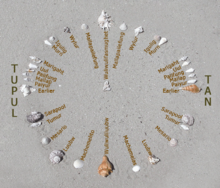
The positions of the stars helped guide Polynesian voyages. Stars, as opposed to planets, hold fixed celestial positions year-round, changing only their rising time with the seasons. Each star has a specific declination, and can give a bearing for navigation as it rises or sets. Polynesian voyagers would set a heading by a star near the horizon, switching to a new one once the first rose too high. A specific sequence of stars would be memorized for each route.[20] The Polynesians also took measurements of stellar elevation to determine their latitude. The latitudes of specific islands were also known, and the technique of "sailing down the latitude" was used.
Some star compass systems specify as many as 150 stars with known bearings, though most systems have only a few dozen (illustration at right).[23][24] The development of sidereal compasses has been studied[25] and hypothesized to have developed from an ancient pelorus instrument.[19]
For navigators near the equator, celestial navigation is simplified, given that the whole celestial sphere is exposed. Any star that passes through the zenith (overhead) moves along the celestial equator, the basis of the equatorial coordinate system.
Swell[]
The Polynesians also used wave and swell formations to navigate. Many of the habitable areas of the Pacific Ocean are groups of islands (or atolls) in chains hundreds of kilometres long. Island chains have predictable effects on waves and currents. Navigators who lived within a group of islands would learn the effect various islands had on the swell shape, direction, and motion, and would have been able to correct their path accordingly. Even when they arrived in the vicinity of an unfamiliar chain of islands, they may have been able to detect signs similar to those of their home.
Once they had arrived fairly close to a destination island, they would have been able to pinpoint its location by sightings of land-based birds, certain cloud formations, as well as the reflections of shallow water made on the undersides of clouds. It is thought that the Polynesian navigators may have measured sailing time between islands in "canoe-days".[19]
The energy transferred from the wind to the sea produces wind waves. The waves that are created when the energy travels down away from the source area (like ripples) are known as swell. When the winds are strong at the source area, the swell is larger. The longer the wind blows, the longer the swell lasts. Because the swells of the ocean can remain consistent for days, navigators relied on them to carry their canoe in a straight line from one house (or point) on the star compass to the opposite house of the same name. Navigators were not always able to see stars; because of this, they relied on the swells of the ocean. Swell patterns are a much more reliable method of navigation than waves, which are determined by the local winds. Swells move in a straight direction which makes it easier for the navigator to determine whether the canoe is heading in the correct direction.[26]
[]
There is currently no evidence of historic Polynesian navigators using navigational devices on board vessels.[27] However, the Micronesian people of the Marshall Islands have a history of using a stick chart onshore, to serve as spatial representations of islands and the conditions around them.
Extent of voyaging[]

On his first voyage of Pacific exploration, Captain James Cook had the services of a Polynesian navigator, Tupaia, who drew a chart of the islands within a 2,000 miles (3,200 km) radius (to the north and west) of his home island of Ra'iatea. Tupaia had knowledge of 130 islands and named 74 on his chart.[28] Tupaia had navigated from Ra'iatea in short voyages to 13 islands. He had not visited western Polynesia, as since his grandfather's time the extent of voyaging by Raiateans had diminished to the islands of eastern Polynesia. His grandfather and father had passed to Tupaia the knowledge as to the location of the major islands of western Polynesia and the navigation information necessary to voyage to Fiji, Samoa and Tonga.[29] Tupaia was hired by Joseph Banks, the ship's naturalist, who wrote that Cook ignored Tupaia's chart and downplayed his skills as a navigator.[30]
However, in February 1778, Cook recorded his impressions of the dispersal and settlement of Polynesian people across the Pacific ocean in favorable terms:[31]
How shall we account for this nation's having spread itself, in so many detached islands, so widely disjoined from each other in every quarter of the Pacific Ocean? We find it, from New Zealand, in the South, as far as the Sandwich Islands (Hawai'i), to the North, and, in another direction, from Easter Island, to the Hebrides (Vanuatu); that is, over an extent of sixty degrees of latitude, or twelve hundred leagues north and south, and eighty-three degrees of longitude, or sixteen hundred and sixty leagues east and west! How much farther in either direction its colonies reach is not known; but what we know already; in consequence of this and our former voyage, warrants our pronouncing it to be, though perhaps not the most numerous, certainly by far the most extensive, nation upon earth.
Subantarctic and Antarctica[]

There is academic debate on the furthest southern extent of Polynesian expansion.
The islands of New Zealand, along with a series of outlying islands, have been labelled 'South Polynesia' by New Zealand archaeologist Atholl Anderson.[32] These islands include the Kermadec Islands, the Chatham Islands, the Auckland Islands and Norfolk Island. In each of these islands there is radio carbon dating evidence of visits from Polynesians by 1500.[32] The material evidence of Polynesian visits to at least one of the subantarctic islands to the south of New Zealand consists of the remains of a settlement. This evidence from Enderby Island in the Auckland Islands has been radio carbon dated back to the 13th Century.[33][34][35][36]
Descriptions of a shard of early Polynesian pottery buried on the Antipodes Islands[37] are unsubstantiated, and the Museum of New Zealand Te Papa Tongarewa, where it was supposedly stored, has stated that "The Museum has not been able to locate such a shard in its collection, and the original reference to the object in the Museum's collection documentation indicates no reference to Polynesian influences."[38]
Oral history describes Ui-te-Rangiora, around the year 650, leading a fleet of Waka Tīwai south until they reached, "a place of bitter cold where rock-like structures rose from a solid sea".[39] The brief description might match the Ross Ice Shelf or possibly the Antarctic mainland,[40] but may be a description of icebergs surrounded by sea Ice found in the Southern Ocean.[41][42] The account also describes snow.
Pre-Columbian contact with the Americas[]
In the mid-20th century, Thor Heyerdahl proposed a new theory of Polynesian origins (one which did not win general acceptance), arguing that the Polynesians had migrated from South America on balsa-log boats.[43][44]
The presence in the Cook Islands of sweet potatoes, a plant native to the Americas (called kūmara in Māori), which have been radiocarbon-dated to 1000 CE, has been cited as evidence that Native Americans could have traveled to Oceania. The current thinking is that sweet potato was brought to central Polynesia circa 700 CE and spread across Polynesia from there, possibly by Polynesians who had traveled to South America and back.[45] An alternative explanation posits biological dispersal; plants and/or seeds could float across the Pacific without any human contact.[46]
A 2007 study published in the Proceedings of the National Academy of Sciences examined chicken bones at near the Arauco Peninsula. The results suggested Oceania-to-America contact. The domestication of chickens originated in southern Asia, whereas the Araucana breed of Chile is thought to have been introduced to the Americas by Spaniards around 1500. The bones found in Chile were radiocarbon-dated to between 1304 and 1424, prior to the documented arrival of the Spanish. DNA sequences taken were exact matches to the sequences of chickens from the same period in American Samoa and Tonga, both over 5000 miles (8000 kilometers) away from Chile. The genetic sequences were also similar to those found in Hawaiʻi and Easter Island, the closest Polynesian island, at only 2500 miles (4000 kilometers). The sequences did not match any breed of European chicken.[47][48][49] Although this initial report suggested a Polynesian pre-Columbian origin, a later report looking at the same specimens concluded:[50]
A published, apparently pre-Columbian, Chilean specimen and six pre-European Polynesian specimens also cluster with the same European/Indian subcontinental/Southeast Asian sequences, providing no support for a Polynesian introduction of chickens to South America. In contrast, sequences from two archaeological sites on Easter Island group with an uncommon haplogroup from Indonesia, Japan, and China and may represent a genetic signature of an early Polynesian dispersal. Modeling of the potential marine carbon contribution to the Chilean archaeological specimen casts further doubt on claims for pre-Columbian chickens, and definitive proof will require further analyses of ancient DNA sequences and radiocarbon and stable isotope data from archaeological excavations within both Chile and Polynesia.
However, in a later study, the original authors extended and elaborated their findings, concluding:[51]
This comprehensive approach demonstrates that the examination of modern chicken DNA sequences does not contribute to our understanding of the origins of Chile’s earliest chickens. Interpretations based on poorly sourced and documented modern chicken populations, divorced from the archeological and historical evidence, do not withstand scrutiny. Instead, this expanded account will confirm the pre-Columbian age of the El Arenal remains and lend support to our original hypothesis that their appearance in South America is most likely due to Polynesian contact with the Americas in prehistory.
Since the late 1980s, the dates and anatomical features of human remains found in Mexico and South America have led some archeologists[who?] to propose that those regions were first populated by people who crossed the Pacific several millennia before the Ice Age migrations; according to this theory, these would have been either eliminated or absorbed by the Siberian immigrants. However, current archeological evidence for human migration to and settlement of remote Oceania (i.e., the Pacific Ocean eastwards of the Solomon Islands) is dated to no earlier than approximately 3,500 BP;[52] trans-Pacific contact with the Americas coinciding with or pre-dating the Beringia migrations of at least 11,500 BP is highly problematic, except for movement along intercoastal routes.
In 2005, a linguist and an archeologist proposed contacts between Polynesians and the Chumash and Gabrielino of Southern California, between 500 and 700.[clarification needed][53] Their primary evidence consisted of the advanced sewn-plank canoe design, which is used throughout the Polynesian Islands, but is unknown in North America – except for those two tribes. Moreover, the Chumash word for "sewn-plank canoe", , may have been derived from kumulaa'au, a Hawaiian word meaning "useful tree".
Polynesian contact with the prehispanic Mapuche culture in central-south Chile has been suggested because of apparently similar cultural traits, including words like toki (stone axes and adzes), hand clubs similar to the Māori wahaika, the sewn-plank canoe as used on Chiloe island, the curanto earth oven (Polynesian umu) common in southern Chile, fishing techniques such as stone wall enclosures, a hockey-like game, and other potential parallels. Some strong westerlies and El Niño wind blow directly from central-east Polynesia to the Mapuche region, between Concepción and Chiloe. A direct connection from New Zealand is possible, sailing with the Roaring Forties. In 1834, some escapees from Tasmania arrived at Chiloe Island after sailing for 43 days.[54][55]
Post-colonial research history[]

Knowledge of the traditional Polynesian methods of navigation was widely lost after contact with and colonization by Europeans. This caused debates over the reasons for the presence of the Polynesians in such isolated and scattered parts of the Pacific. According to , the explorer Captain James Cook, already familiar with Charles de Brosses's accounts of large groups of Pacific islanders who were driven off course in storms and ended up hundreds of miles away with no idea where they were, encountered in the course of one of his own voyages a castaway group of Tahitians who had become lost at sea in a gale and blown 1000 miles away to the island of Atiu. Cook wrote that this incident "will serve to explain, better than the thousand conjectures of speculative reasoners, how the detached parts of the earth, and, in particular, how the South Seas, may have been peopled".[56]
By the late 19th century to the early 20th century, a more generous view of Polynesian navigation had come into favor, creating a much romanticized view of their seamanship, canoes, and navigational expertise. Late 19th- and early 20th-century writers such as Abraham Fornander and Percy Smith told of heroic Polynesians migrating in great coordinated fleets from Asia far and wide into present-day Polynesia.[44]
Another view was presented by Andrew Sharp, who challenged the "heroic vision" hypothesis, asserting instead that Polynesian maritime expertise was severely limited in the field of exploration, and that as a result, the settlement of Polynesia had been the result of luck, random island sightings, and drifting, rather than as organized voyages of colonization. Thereafter, the oral knowledge passed down for generations allowed for eventual mastery of traveling between known locations.[57] Sharp's reassessment caused a huge amount of controversy and led to a stalemate between the romantic and the skeptical views.[44]
Re-creation of voyages[]

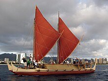
Anthropologist David Lewis sailed his catamaran from Tahiti to New Zealand using stellar navigation without instruments.[58] Anthropologist and historian Ben Finney built Nalehia, a 40-foot (12 m) replica of a Hawaiian double canoe. Finney tested the canoe in a series of sailing and paddling experiments in Hawaiian waters. At the same time, ethnographic research in the Caroline Islands in Micronesia brought to light the fact that traditional stellar navigational methods were still very much in everyday use there. The building and testing of proa canoes (wa) inspired by traditional designs, the harnessing of knowledge from skilled Micronesians, as well as voyages using stellar navigation, allowed practical conclusions about the seaworthiness and handling capabilities of traditional Polynesian canoes and allowed a better understanding of the navigational methods that were likely to have been used by the Polynesians and of how they, as people, were adapted to seafaring.[59] Recent re-creations of Polynesian voyaging have used methods based largely on Micronesian methods and the teachings of a Micronesian navigator, Mau Piailug.[60]
In 1973, Ben Finney established the Polynesian Voyaging Society to test the contentious question of how Polynesians found their islands. The team claimed to be able to replicate ancient Hawaiian double-hulled canoes capable of sailing across the ocean using strictly traditional voyaging techniques.[61] In 1980, a Hawaiian named Nainoa Thompson invented a new method of non-instrument navigation (called the "modern Hawaiian wayfinding system"), enabling him to complete the voyage from Hawaiʻi to Tahiti and back. In 1987, a Māori named Matahi Whakataka (Greg Brightwell) and his mentor Francis Cowan sailed from Tahiti to New Zealand without instruments.[citation needed]
In New Zealand, a leading Māori navigator and ship builder was Hector Busby, who was also inspired and influenced by Nainoa Thompson and Hokulea's voyage there in 1985.[62]
In 2008, an expedition starting in the Philippines sailed two modern Wharram-designed catamarans loosely based on a Polynesian catamaran found in Auckland Museum. The boats were built in the Philippines by an experienced boat builder to Wharram designs using modern strip plank with epoxy resin glue built over plywood frames. The catamarans had modern Dacron sails, Terylene stays and sheets with modern roller blocks. Wharram says he used Polynesian navigation to sail along the coast of Northern New Guinea and then sailed 150 miles to an island for which he had modern charts, proving that it is possible to sail a modern catamaran along the path of the Lapita Pacific migration.[63] Unlike many other modern Polynesian "replica" voyages, the Wharram catamarans were at no point towed or escorted by a modern vessel with modern GPS navigation system, nor were they fitted with a motor.
In 2010, O Tahiti Nui Freedom, an outrigger sailing canoe, retraced the path of the migration from Tahiti to China via Cooks, Tonga, Fiji, Vanuatu, Solomons, PNG, Palau, Philippines in 123 days.[64]
See also[]
- Fautasi
- Hokulea
- Māori migration canoes
Notes[]
- ^ Bellwood, Peter (1978). The Polynesians Prehistory of an Island People. NY: Thames and Hudson. pp. 39. ISBN 9780500020937.
- ^ Clark, Liesl (15 February 2000). "Polynesia's Genius Navigators". Retrieved 17 November 2016.
- ^ Bellwood, Peter (1978). The Polynesians Prehistory of an Island People. NY: Thames and Hudson. pp. 42. ISBN 9780500020937.
- ^ Howe, K. R (2006), Vaka Moana: Voyages of the Ancestors – the discovery and settlement of the Pacific, Albany, Auckland: David Bateman, pp. 92–98
- ^ Kayser, M.; Brauer, S.; Weiss, G.; Underhill, P.A.; Roewer, L.; Schiefenhövel, W.; Stoneking, M. (2000), "Melanesian Origin of Polynesian Y Chromosomes", Current Biology, 10 (20): 1237–1246, doi:10.1016/S0960-9822(00)00734-X, PMID 11069104
- ^ Kayser, M.; Brauer, S.; Weiss, G.; Underhill, P.A.; Roewer, L.; Schiefenhövel, W.; Stoneking, M. (2001), "Correction: Melanesian Origin of Polynesian Y Chromosomes", Current Biology, 11 (2): I–II, doi:10.1016/S0960-9822(01)00029-X
- ^ Bellwood 1987, pp. 45–65.
- ^ "Lapita culture: ancestors of Polynesians, Micronesians, and some coastal areas of Melanesia". Originalpeople.org. Retrieved 11 April 2018.
- ^ Walter, Richard; Dickenson, W. R. (1989). "A Ceramic Sherd from Ma'uke in the Southern Cook Islands". The Journal of the Polynesian Society. 98 (4): 465–470. JSTOR 20706311 – via JSTOR.
- ^ E. Tetahiotupa, Au gré des vents et des courants () 2009.
- ^ Niespolo, Elizabeth M.; Sharp, Warren D.; Kirch, Patrick V. (2019). "230TH dating of coral abraders from stratified deposits at Tangatatau Rockshelter, Mangaia, Cook Islands: Implications for building precise chronologies in Polynesia". Journal of Archaeological Science. 101: 21–33. doi:10.1016/j.jas.2018.11.001 – via Elsevier Science Direct.
- ^ Howe, K.R., ed. (2006). Vaka Moana. Honolulu, HI: University of Hawaii Press. ISBN 0824832132.
- ^ Bellwood 1987, pp. 29, 54.
- ^ Bayard, D. T. (1976). The Cultural Relationships of the Polynesian Outliers. Otago University, Studies in Prehistoric Anthropology, Vol. 9.
- ^ Kirch, P. V. (1984). "The Polynesian Outliers: Continuity, change, and replacement". Journal of Pacific History. 19 (4): 224–238. doi:10.1080/00223348408572496.
- ^ Gill, William W. (1876). Songs and Myths from the South Pacific (1977 ed.). London: H.S. King. ISBN 0524008388.
- ^ Kamakau, S.M. (1961). Ruling Chiefs of Hawaii. Honolulu, HI: Kamehameha Publishing. ISBN 0873360141.
- ^ Thompson, Nainoa. "On Wayfinding". Polynesian Voyaging Society. Retrieved 11 April 2018.
- ^ Jump up to: a b c d Gatty 1958.
- ^ Jump up to: a b Lewis, David (1972). We, the Navigators. HI: University of Hawaii Press. ISBN 9780824802295.
- ^ "Be Your Own Navigator," Smithsonian Libraries Unbound, 11 February 2016.
- ^ "Star Compasses". Polynesian Voyaging Society. Archived from the original on 5 August 2010.
- ^ Harold Gatty (1958). Nature Is Your Guide, p. 45
- ^ Star Compass diagrams with translations
- ^ Halpern, M. D. (1985) The Origins of the Carolinian Sidereal Compass, Master's thesis, Texas A & M University
- ^ Gooley, Tristan (2016). How to Read Water: Clues, Signs & Patterns from Puddles to the Sea. NY: Hodder & Stoughton. ISBN 9781473615205.
- ^ Howe, K. R., ed. (2006). Vaka Moana: Voyages of the Ancestors. Auckland, New Zealand: Bateman. p. 175–177. ISBN 9781869536251.
- ^ Druett, Joan (1987). Tupaia – The Remarkable Story of Captain Cook's Polynesian Navigator. New Zealand: Random House. pp. 226–227.
- ^ Druett, Joan (1987). Tupaia – The Remarkable Story of Captain Cook's Polynesian Navigator. New Zealand: Random House. pp. 218–233.
- ^ O'Sullivan, Dan (2008). In search of Captain Cook. I.B. Taurus. p. 148. ISBN 9781845114831.
- ^ Crowe, p236
- ^ Jump up to: a b Anderson A, Binney J, Harris A (2015). Tangata Whenua, A History. Bridget Williams Books. p. 28. ISBN 9780908321537.CS1 maint: multiple names: authors list (link)
- ^ O'Connor, Tom Polynesians in the Southern Ocean: Occupation of the Auckland Islands in Prehistory in New Zealand Geographic 69 (September–October 2004): 6–8
- ^ Anderson, Atholl J., & Gerard R. O'Regan "To the Final Shore: Prehistoric Colonisation of the Subantarctic Islands in South Polynesia" in Australian Archaeologist: Collected Papers in Honour of Jim Allen Canberra: Australian National University, 2000. 440–454.
- ^ Anderson, Atholl J., & Gerard R. O'Regan The Polynesian Archaeology of the Subantarctic Islands: An Initial Report on Enderby Island Southern Margins Project Report. Dunedin: Ngai Tahu Development Report, 1999
- ^ Anderson, Atholl J. (2005). "Subpolar Settlement in South Polynesia". Antiquity. 79 (306): 791–800. doi:10.1017/S0003598X00114930.
- ^ "Nga-Iwi-o-Aotea". Te Ao Hou (59): 43. 1967.
- ^ "Captain Fairchild to the Secretary, Marine Department, Wellington". Appendix to the Journals of the House of Representatives, 1886 Session I, H-24 Page 6.
- ^ "Expedition Cruises Fathom Expeditions Custom Cruise". Archived from the original on 23 June 2010. Retrieved 2 March 2016.
- ^ "All About Antarctica". Archived from the original on 4 September 2011. Retrieved 2 March 2016.
- ^ "The Left Coaster: freeze frame". Retrieved 2 March 2016.
- ^ "Ui-te-Rangiora". Encyclopædia Britannica. Retrieved 2 March 2016.
- ^ Sharp 1963, pp. 122–128.
- ^ Jump up to: a b c Finney 1963, p. 5.
- ^ Van Tilburg, Jo Anne (1994). Easter Island: Archaeology, Ecology and Culture. Washington, DC: Smithsonian Institution Press.
- ^ Montenegro, A.; et al. "Modeling the prehistoric arrival of the sweet potato in Polynesia" (PDF). Journal of Archaeological Science. University of Victoria. Archived from the original (PDF) on 28 June 2011. Retrieved 6 September 2011.
- ^ Whipps, Heather (4 June 2007), "Chicken Bones Suggest Polynesians Found Americas Before Columbus", Live Science, retrieved 5 June 2007.
- ^ Maugh, Thomas H., II (5 June 2007). "Polynesians beat Spaniards to South America, study shows". Los Angeles Times.
- ^ Storey, A. A.; et al. (2007). "Radiocarbon and DNA evidence for a pre-Columbian introduction of Polynesian chickens to Chile". Proceedings of the National Academy of Sciences. 104 (25): 10335–10339. Bibcode:2007PNAS..10410335S. doi:10.1073/pnas.0703993104. PMC 1965514. PMID 17556540.
- ^ Gongora, J.; et al. (2008). "Indo-European and Asian origins for Chilean and Pacific chickens revealed by mtDNA". Proceedings of the National Academy of Sciences. 105 (30): 10308–10313. Bibcode:2008PNAS..10510308G. doi:10.1073/pnas.0801991105. PMC 2492461. PMID 18663216.
- ^ Storey, Alice A.; Quiroz, Daniel; Beavan, Nancy; Matisoo-Smith, Elizabeth (2013). "Polynesian Chickens in the New World: a detailed application of a commensal approach". Archaeology in Oceania. 48 (2): 101–119. doi:10.1002/arco.5007.
- ^ Kirch, Patrick V. Background to Pacific Archaeology and Prehistory Archived 9 June 2007 at the Wayback Machine, Oceanic Archaeology Laboratory, Univ. California, Berkeley.
- ^ Klaar, Kathryn A.; Jones, Terry L. (Winter 2005). "Linguistic Evidence for a Prehistoric Polynesia: Southern California Contact Event". Anthropological Linguistics. 47 (4): 369–400. JSTOR 25132351. Retrieved 28 September 2020.
- ^ "Rapa Nui" (in Spanish). Archived from the original on 6 June 2007. Retrieved 5 June 2007.
- ^ Lewis, David (1972). We, the Navigators: The Ancient Art of Landfinding in the Pacific. Canberra: Australian National University Press.
- ^ Sharp 1963, p. 16.
- ^ Sharp 1963.
- ^ Lewis 1976.
- ^ Finney 1963, pp. 6–9.
- ^ See also: Polynesian Voyaging Society, Hokulea.
- ^ Finney, Ben. "Voyaging into Polynesia's Past The Founding of the Polynesian Voyaging Society". Hokule'a. Retrieved 11 April 2018.
- ^ "Profile: Hekenukumai (Hector) Busby". Toi Māori Aotearoa. Archived from the original on 11 October 2014. Retrieved 12 October 2014.
- ^ Hympendahl, Klaus. "Lapita Voyage – The first expedition following the migration route of the ancient Polynesians". Archived from the original on 3 March 2016. Retrieved 2 March 2016.
- ^ "Tahiti: Maritime Culture". SEA Semester. Retrieved 11 April 2019.
References[]
- Bellwood, Peter (1987). The Polynesians – Prehistory of an Island People. Thames and Hudson. pp. 45–65. ISBN 9780500274507.
- Crowe, Andrew (2018). Pathway of the Birds: The Voyaging Achievements of the Maori and Their Polynesian Ancestors. David Bateman Ltd. ISBN 978-1-86953-961-0.
- Downes, Lawrence (16 July 2010), "Star Man", New York Times.
- Finney, Ben R (1963), "New, Non-Armchair Research", in Finney, Ben R (ed.), Pacific Navigation and Voyaging, The Polynesian Society.
- Finney, Ben R, ed. (1976), Pacific Navigation and Voyaging, The Polynesian Society.
- Gatty, Harold (1943), The Raft Book: Lore of Sea and Sky, U.S. Air Force.
- Gatty, Harold (1958), Finding Your Way Without Map or Compass, Dover Publications, ISBN 978-0-486-40613-8.
- King, Michael (2003), History of New Zealand, Penguin Books, ISBN 978-0-14-301867-4.
- Lewis, David (1963), "A Return Voyage Between Puluwat and Saipan Using Micronesian Navigational Techniques", in Finney, Ben R (ed.), Pacific Navigation and Voyaging, The Polynesian Society.
- Lewis, David (1994), We the Navigators: The Ancient art of Landfinding in the Pacific, University of Hawaii Press.
- Lusby, et al. (2009/2010) "Navigation and Discovery in the Polynesian Oceanic Empire" Hydrographic Journal Nos. 131, 132, 134.
- Sharp, Andrew (1963), Ancient Voyagers in Polynesia, Longman Paul Ltd..
- Sutton, Douglas G., ed. (1994), The Origins of the First New Zealanders, Auckland University Press.
External links[]
- Kawaharada, Dennis. "Wayfinding: Modern Methods and Techniques of Non-Instrument Navigation, Based on Pacific Traditions". Wayfinding Strategies and Tactics. Honolulu, HI, USA: Polynesian Voyaging Society. Retrieved 26 November 2012.
- "Wayfinding". Honolulu, HI, USA: Polynesian Voyaging Society. Archived from the original on 17 September 2009. Retrieved 26 November 2012.
- Exploratorium. "Never Lost | Polynesian Navigation" (Flash). San Francisco, CA, USA: Exploratorium. Retrieved 26 November 2012. An interactive presentation with English and Hawaiian language options.
| show Austronesian ships |
|---|


- Polynesian navigation
- Navigation
- History of navigation
- Polynesian culture
- Ancient Hawaii
- Polynesian navigators
- Prehistoric migrations
- Māori science