Pompierre, les Saintes
Pompierre | |
|---|---|
Quartier | |
 | |
| Coordinates: 15°52′19″N 61°34′15″W / 15.87194°N 61.57083°WCoordinates: 15°52′19″N 61°34′15″W / 15.87194°N 61.57083°W | |
| Country | |
| Overseas department | |
| Canton | les Saintes |
| commune | Terre-de-Haut |

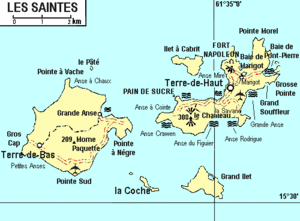
Pompierre is a quartier of Terre-de-Haut Island, located in Îles des Saintes archipelago in the Caribbean. It is located in the northeastern part of the island. The Beach of is situated on this quartier.
This Guadeloupe location article is a stub. You can help Wikipedia by . |
Categories:
- Populated places in Îles des Saintes
- Quartiers of Îles des Saintes
- Guadeloupe geography stubs