Ponta Preta (Northern Sal)
| Ponta Preta | |
|---|---|
 | |
| Location | Northern Sal, Cape Verde |
| Coordinates | 16°49′31″N 22°59′06″W / 16.8254°N 22.985°WCoordinates: 16°49′31″N 22°59′06″W / 16.8254°N 22.985°W |
| Offshore water bodies | Atlantic Ocean |
Ponta Preta (Portuguese meaning "black tip") is a headland in the northwest of the island of Sal in Cape Verde, known as one of the best kitesurfing and windsurfing locales on the island for experienced surfers due to the strong cross off-shore winds.[1][2] It is approximately 9 km northwest of the island capital of Espargos.[citation needed] The nearest settlement is Terra Boa, 5 km to the southeast. The headland is approximately 28 meters above sea level.[3]
References[]
- ^ Guide, The Kite and Windsurfing. "Ponta Preta". KITE AND WINDSURFING GUIDE. Retrieved 2022-03-17.
- ^ "Kitesurf Cabo Verde | Ponta Preta or Kite Beach in Sal or the island of Boa Vista may be good spots for you". Retrieved 2022-03-17.
- ^ "Ponta Preta point, Sal, Cape Verde". cv.geoview.info. Retrieved 2022-03-17.
The island of Sal, Cape Verde | ||
|---|---|---|
| Settlements | 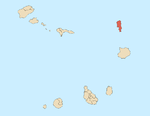 | |
| Mountains and hills |
| |
| Points and promontories |
| |
| Lighthouses |
| |
| Other geographical features |
| |
| Other topics | ||
Categories:
- Geography of Sal, Cape Verde
- Headlands of Cape Verde