Poquonock Bridge, Connecticut
Poquonock Bridge | |
|---|---|
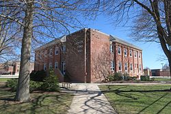
 Groton Town Hall | |
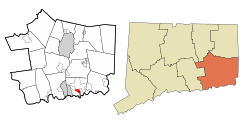
 Location in New London County, Connecticut | |
| Coordinates: 41°20′42″N 72°01′29″W / 41.34500°N 72.02472°WCoordinates: 41°20′42″N 72°01′29″W / 41.34500°N 72.02472°W | |
| Country | United States |
| State | Connecticut |
| County | New London |
| Town | Groton |
| Area | |
| • Total | 1.4 sq mi (3.7 km2) |
| • Land | 1.4 sq mi (3.5 km2) |
| • Water | 0.077 sq mi (0.2 km2) |
| Elevation | 98 ft (30 m) |
| Population (2010) | |
| • Total | 1,727 |
| • Density | 1,200/sq mi (470/km2) |
| Time zone | UTC−5 (Eastern (EST)) |
| • Summer (DST) | UTC−4 (EDT) |
| ZIP code | 06340 |
| Area code(s) | 860 |
| FIPS code | 09-61730 |
| GNIS feature ID | 2377852[1] |
Poquonnock Bridge is a village and census-designated place (CDP) in the town of Groton in New London County, Connecticut, United States. The population was 1,727 at the 2010 census.[2]
The village is located just east of the head of the near the intersection of U.S. Route 1 and Connecticut Route 117. The village was first settled in 1652–53 by , James Avery, and . The Groton Town Hall is located in the village.
Geography[]
According to the United States Census Bureau, the CDP has a total area of 1.4 square miles (3.7 km2), of which 1.4 square miles (3.5 km2) is land, and 0.077 square miles (0.2 km2) (5.07%) is water.[3]
Demographics[]
As of the census[4] of 2000, there were 1,592 people, 588 households, and 415 families residing in the CDP. The population density was 1,165.8 people per square mile (448.7/km2). There were 630 housing units at an average density of 461.3 per square mile (177.6/km2). The racial makeup of the CDP was 65.45% White, 14.13% African American, 3.83% Native American, 8.04% Asian, 0.25% Pacific Islander, 1.76% from other races, and 6.53% from two or more races. Hispanic or Latino of any race were 6.16% of the population.
There were 588 households, out of which 38.9% had children under the age of 18 living with them, 41.8% were married couples living together, 22.4% had a female householder with no husband present, and 29.3% were non-families. 23.5% of all households were made up of individuals, and 7.7% had someone living alone who was 65 years of age or older. The average household was 2.71 person, and the average family size was 3.14.
In the CDP, the population was spread out, with 29.8% under the age of 18, 9.2% from 18 to 24, 31.3% from 25 to 44, 19.3% from 45 to 64, and 10.4% who were 65 years of age or older. The median age was 33 years. For every 100 females, there were 95.8 males. For every 100 females age 18 and over, there were 91.4 males.
The median income for a household in the CDP was $33,652, and the median income for a family was $35,592. Males had a median income of $24,219 versus $21,250 for females. The per capita income for the CDP was $14,664. About 11.2% of families and 15.5% of the population were below the poverty line, including 23.5% of those under age 18, and 5.4% of those age 65 or over.
References[]
- ^ U.S. Geological Survey Geographic Names Information System: Poquonock Bridge
- ^ "Profile of General Population and Housing Characteristics: 2010 Demographic Profile Data (DP-1): Poquonnock Bridge CDP, Connecticut". United States Census Bureau. Retrieved October 29, 2012.
- ^ "Geographic Identifiers: 2010 Demographic Profile Data (G001): Poquonnock Bridge CDP, Connecticut". United States Census Bureau. Retrieved October 29, 2012.
- ^ "U.S. Census website". United States Census Bureau. Retrieved January 31, 2008.
- Groton, Connecticut
- Census-designated places in New London County, Connecticut
- Villages in Connecticut
- Populated places established in 1652
- 1652 establishments in Connecticut
- Villages in New London County, Connecticut
- Census-designated places in Connecticut

