Porcupine Ridge
| Porcupine Ridge | |
|---|---|
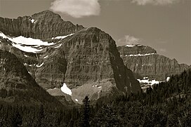 Northeast aspect Summit upper left, The Guardhouse behind right | |
| Highest point | |
| Elevation | 9,128 ft (2,782 m)[1] |
| Prominence | 1,688 ft (515 m)[1] |
| Parent peak | The Guardhouse (9,341 feet)[2] |
| Isolation | 1.57 mi (2.53 km)[2] |
| Coordinates | 48°55′12″N 113°59′00″W / 48.92002067°N 113.98323568°WCoordinates: 48°55′12″N 113°59′00″W / 48.92002067°N 113.98323568°W[3] |
| Geography | |
 Porcupine Ridge Location in Montana | |
| Location | Glacier National Park Glacier County, Montana, U.S. |
| Parent range | Livingston Range Rocky Mountains |
| Topo map | USGS Porcupine Ridge |
| Geology | |
| Age of rock | Precambrian |
| Type of rock | Sedimentary rock |


Porcupine Ridge is a prominent mountain ridge located in the Goat Haunt area of Glacier National Park, in Glacier County of the U.S. state of Montana.[3] This mountain is part of the Livingston Range, and is situated 1.5 mile east of the Continental Divide. Topographic relief is significant as the summit rises approximately 3,900 feet (1,190 meters) above Lake Frances in one mile, and nearly 5,000 feet (1,524 meters) above Waterton Lake in five miles. Precipitation runoff from the mountain drains to the Waterton River via Olson and Valentine Creeks. This geographical feature's name was officially adopted in 1911 by the United States Board on Geographic Names.[3]
Climate[]
Based on the Köppen climate classification, Porcupine Ridge is located in an alpine subarctic climate zone characterized by long, usually very cold winters, and short, cool to mild summers.[4] Temperatures can drop below −10 °F with wind chill factors below −30 °F. This climate supports the remnant of an unnamed glacier on the northeast aspect below the summit.[5]
Geology[]
Like the mountains in Glacier National Park, Porcupine Ridge is composed of sedimentary rock laid down during the Precambrian to Jurassic periods. Formed in shallow seas, this sedimentary rock was initially uplifted beginning 170 million years ago when the Lewis Overthrust fault pushed an enormous slab of precambrian rocks 3 mi (4.8 km) thick, 50 miles (80 km) wide and 160 miles (260 km) long over younger rock of the cretaceous period.[6]
Gallery[]
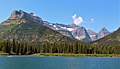
Porcupine Ridge centered (cloud over the summit), with Citadel Peaks (left).
Porcupine Ridge (left) seen from Goat Haunt Ranger Station

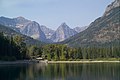
Porcupine Ridge left of center, Olson Mountain to right.

South aspect, circa 1913.
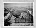
Porcupine Ridge to right, aerial view circa 1925.


See also[]
- List of mountains and mountain ranges of Glacier National Park (U.S.)
- Geology of the Rocky Mountains
References[]
- ^ a b "Porcupine Ridge, Montana". Peakbagger.com. Retrieved 2021-10-18.
- ^ a b "Porcupine Ridge - 9,128' MT". listsofjohn.com. Retrieved 2021-10-18.
- ^ a b c "Porcupine Ridge". Geographic Names Information System. United States Geological Survey. Retrieved 2021-10-18.
- ^ Peel, M. C.; Finlayson, B. L.; McMahon, T. A. (2007). "Updated world map of the Köppen−Geiger climate classification" (PDF). Hydrol. Earth Syst. Sci. 11 (5): 1633���1644. Bibcode:2007HESS...11.1633P. doi:10.5194/hess-11-1633-2007. ISSN 1027-5606.
- ^ Scribner's Magazine, Volume 65, 1919, page 397.
- ^ Gadd, Ben (2008). "Geology of the Rocky Mountains and Columbias".
{{cite journal}}: Cite journal requires|journal=(help)
External links[]
- Weather forecast: Porcupine Ridge
- National Park Service web site: Glacier National Park
- Porcupine Ridge fire lookout (photo): Flickr
Places adjacent to Porcupine Ridge | |
|---|---|
- Livingston Range
- Mountains of Glacier County, Montana
- Mountains of Glacier National Park (U.S.)
- Mountains of Montana
- North American 2000 m summits