Port of Mangalia
| Port of Mangalia | |
|---|---|
 | |
| Location | |
| Country | Romania |
| Location | Constanța County |
| Coordinates | 43°49′N 28°35′E / 43.817°N 28.583°ECoordinates: 43°49′N 28°35′E / 43.817°N 28.583°E |
| UN/LOCODE | ROMAG[1] |
| Details | |
| Owned by | Compania Naționalǎ Administrația Porturilor Maritime Constanța |
| Type of harbor | Natural/Artificial |
| Size of harbor | 1.15 square kilometres |
| Land area | 0.27 square kilometres |
| Size | 142.2 hectares (1.42 square kilometres) |
| Available berths | 4 |
| General manager | Constantin Matei |
| Statistics | |
| Annual cargo tonnage | 203,000 tonnes[2] (2006) |
| Website www.portofconstantza.com/mangalia | |

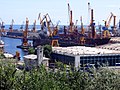
The Port of Mangalia is situated on the Black Sea, located in the city of Mangalia close to the southern border with Bulgaria, and over 260 km north of Istanbul. It covers 142.19 ha of which 27.47 ha is land and 114.72 ha is water.
The north and south breakwaters have a total length of 2.74 km. There are 4 berths (2 operational berths) with a total length of 540 m. The max. depth is 9 m.
The Port of Mangalia is mainly used by the Constanța Shipyard.
See also[]
References[]
- ^ "UNLOCODE (RO) - ROMANIA". service.unece.org. Retrieved 27 April 2020.
- ^ Mangalia Port Statistics
This article related to ports, harbors or marinas is a stub. You can help Wikipedia by . |
Categories:
- Ports and harbours of Romania
- Mangalia
- Port stubs