Porto Palermo Castle
| Porto Palermo Castle | |
|---|---|
Kalaja e Porto Palermos | |
| Himarë, Albania | |
 Porto Palermo Castle | |
 Porto Palermo Castle | |
| Coordinates | 40°03′44″N 19°47′26″E / 40.062317°N 19.790475°E |
| Site information | |
| Owner | |
| Controlled by | |
| Site history | |
| Built by | final form created by Ali Pasha of Tepelena |

 | |
 | |
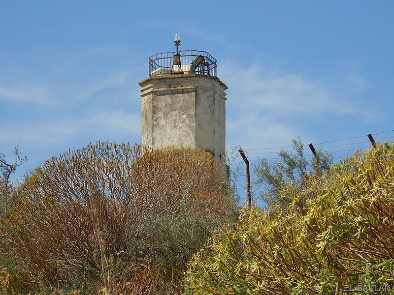
| Location | Kep i Palermos Porto Palermo Albania |
|---|---|
| Coordinates | 40°02′58.9″N 19°47′39.4″E / 40.049694°N 19.794278°E |
| Constructed | n/a |
| Foundation | stone base |
| Construction | stone tower |
| Tower height | 10 metres (33 ft) |
| Tower shape | irregular octagonal tower with balcony and light atop |
| Markings | unpainted tower |
| Power source | solar power |
| Focal height | 113 metres (371 ft) |
| Range | 8 nautical miles (15 km; 9.2 mi)[1] |
| Characteristic | Fl W 8s. |
| NGA no. | 14368 |
| Admiralty no. | E3734 |
| ARLHS no. | ALB-001[2] |

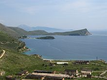
Porto Palermo Castle (Albanian: Kalaja e Porto Palermos) is a castle near Himarë in southern Albania. It is situated in the bay of Porto Palermo, a few kilometers south of Himarë along the Albanian Riviera. Huffington Post ranked Porto Palermo first among 15 Undiscovered European Destinations for 2014.[3] The area together with Llamani beach will be proclaimed a protected area holding the status of Protected Landscape by the Albanian Government.[4]
History[]
This section needs expansion. You can help by . (June 2015) |

The well preserved castle is asserted by guide books and the local tourist guides, to have been built in early 19th century by Ali Pasha of Tepelena.[5][need quotation to verify] In 1921 the castle was called Venetian.[6][need quotation to verify] Porto Palermo Castle is a castle near Himara in southern Albania with an intriguing history. It is situated in the closed bay of Porto Palermo, a few kilometers south of Himarë, and makes nearly an island that is connected to the mainland by a narrow strip of land. The fort served as former Soviet submarine base during the communist regime in Albania, and nowadays its semi abandoned tunnel and barrack attract attention of visitors, as well as the stronghold walls and gates built by the powerful Ali Pasha of Ionina.
However, Porto Palermo had been an ancient Illyrian port-town named Panorë, and it served the fortified city of Himarë; now, the area around Cheimara was inhabited by the Illyrian tribe of the Chaonians before the 5th c. BCE. Panormos is also mentioned by Strabo and by Ptolemy. Most likely, Panorë was renamed during the Byzantine era (perhaps by people from Palermo, Sicily) as Porto Palermo; the original name of Palermo in Sicily was Panorlos.
By the middle of the 17th century the Ottoman Empire system of administration of vilayets of sanjaks /provinces/ changed into the near-autonomous governance of local rulers who were known as pashas. At the end of the 18th century the sultan appointed a certain Ali from Tepelen as the governor of the most of the Epirus /of the present day southern Albania/ and the large part of the Greek mainland, with his court at Ionina – Yannina. The ancestors of Ali were Christian Albanians, and became Muslims under the Turkish invasion. As young fellow, Ali was patrolling highroads and lanes, with his gun on his shoulder and his yataghan in his belt, attacking, holding for ransom, or plundering all whom he encountered. Afer some years of this profitable business, he found himself a wealthy man and came to power with a distinguished and honourable rank among the beys of the country.[citation needed]
The castle would have been vulnerable to cannon fire from the hill above and this also suggests an early date for its construction when cannon had not developed the range they had later.[citation needed] In 1662 the Venetians feared the Turks would recondition it.[7][need quotation to verify] In 1803 Ali Pasha offered the castle and port to the Royal Navy. At which time the fort only had 4 or 5 cannon implying that Ali Pasha did not see the fort as important for him.[8][need quotation to verify] Leake visited the fort and noted that the garrison consisted of 10 men with two four-pounders.[9] Pouqueville in 1806 reports, "The tower or fort stands on the southern point of the entrance, connected with the continent by a low narrow isthmus. It consists of a square with bastions, having a few guns, of no service either to command the entrance or to protect the shipping at anchor. Near it are some warehouses, a custom-house, and a Greek church."[10]
See also[]
- List of lighthouses in Albania
- Tourism in Albania
- Albanian Riviera
- Geography of Albania
- Porto Palermo Tunnel
References[]
- ^ List of Lights, Pub. 113: The West Coasts of Europe and Africa, the Mediterranean Sea, Black Sea and Azovskoye More (Sea of Azov) (PDF). List of Lights. United States National Geospatial-Intelligence Agency. 2015.
- ^ Rowlett, Russ. "Lighthouses of Albania". The Lighthouse Directory. University of North Carolina at Chapel Hill. Retrieved 7 April 2017.
- ^ "15 Undiscovered European Destinations". Huffington Post. 7 April 2014.
- ^ http://www.mjedisi.gov.al/files/userfiles/Transparence_dhe_Pjesmarrje/Draft_VKM-Gjiri_Portopalermos-Llamani_2015.docx
- ^ Ndarurinze, Renate (2008). Albanien entdecken: Auf den Spuren Skanderbegs (in German). Berlin: Trescher Verlag. p. 243. ISBN 978-3-89794-125-0.
- ^ Scriven, George P. (April 1921). "Some Highways of Albania and a Forgotten Riviera". Geographical Review. American Geographical Society. 11 (2): 198–206. doi:10.2307/207325. JSTOR 207325.
- ^ p191 “Eternal Butrint” by R.Hodges 2006 London
- ^ p 86 J. W. BAGGALLY 1938 Ali Pasha and Great Britain Basil Blackwell: Oxford
- ^ "Archived copy". Archived from the original on 2015-10-06. Retrieved 2015-10-06.CS1 maint: archived copy as title (link)
- ^ "Archived copy". Archived from the original on 2016-03-04. Retrieved 2015-10-06.CS1 maint: archived copy as title (link)
External links[]
| Wikimedia Commons has media related to Porto Palermo Castle. |
- Castles in Albania
- Buildings and structures in Himara
- Tourist attractions in Vlorë County
- Lighthouses in Albania