Powder River Pass
- The Powder River Pass is also the name of a football play, taking place between Arkansas and Ole Miss in 1954.
| Powder River Pass | |
|---|---|
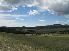 Powder River Pass, looking west | |
| Elevation | 9,666 ft (2,946 m)[1] |
| Traversed by | U.S. Highway 16 |
| Location | Johnson County, Wyoming, United States |
| Range | Bighorn Mountains |
| Coordinates | 44°08′59″N 107°04′46″W / 44.14972°N 107.07944°WCoordinates: 44°08′59″N 107°04′46″W / 44.14972°N 107.07944°W |

Powder River Pass (el. 9666 ft.) is a mountain pass in the Bighorn Mountains in Wyoming traversed by U.S. Highway 16.[1] Also known as Muddy Pass, it is the highest point on Highway 16.[1] It is between the towns of Buffalo and Ten Sleep.[2]
References[]
- ^ a b c Federal Writers' Project (1941). The WPA Guide to Wyoming: The Cowboy State. ISBN 1595342486.
- ^ Shirley Slater; Harry Basch (2010). RV Vacations For Dummies. p. 294. ISBN 0470934131.

The Powder River Pass sign
This article about a location in Wyoming is a stub. You can help Wikipedia by . |
Categories:
- Landforms of Johnson County, Wyoming
- Mountain passes of Wyoming
- Transportation in Johnson County, Wyoming
- Wyoming geography stubs