Prescott Island
- This article is for the island in Nunavut, Canada. For the island in British Columbia, Canada, see Prescott Island (British Columbia).
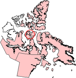 Prescott Island, Nunavut. | |
 Prescott Island | |
| Geography | |
|---|---|
| Location | Northern Canada |
| Coordinates | 73°03′N 096°50′W / 73.050°N 96.833°WCoordinates: 73°03′N 096°50′W / 73.050°N 96.833°W |
| Archipelago | Canadian Arctic Archipelago |
| Area | 412 km2 (159 sq mi) |
| Administration | |
Canada | |
| Territory | Nunavut |
| Region | Qikiqtaaluk |
| Demographics | |
| Population | Uninhabited |


Prescott Island is one of the uninhabited Canadian Arctic islands in the territory of Nunavut. The island is situated in Peel Sound, between the Prince of Wales Island and Somerset Island.
Prescott Island is oval-shaped, and has an area of 412 km2 (159 sq mi). Together with four other, smaller islands (, Lock, Pandora, and Vivian), they create a barrier at the entrance into on eastern Prince of Wales Island.[1]
References[]
- ^ "Prescott Island". oceandots.com. 2006-07-31. Archived from the original on December 23, 2010. Retrieved 2008-05-10.CS1 maint: unfit URL (link)
External links[]
- Prescott Island in the Atlas of Canada - Toporama; Natural Resources Canada
This Qikiqtaaluk Region, Nunavut location article is a stub. You can help Wikipedia by . |
Categories:
- Uninhabited islands of Qikiqtaaluk Region
- Islands of the Canadian Arctic Archipelago
- Islands of Qikiqtaaluk Region
- Qikiqtaaluk Region, Nunavut geography stubs