Prince Leopold Island
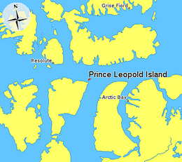 Prince Leopold Island in relation to Grise Fiord, Resolute, and Arctic Bay. | |
 Prince Leopold Island | |
| Etymology | Named after Prince Leopold of Saxe-Coburg-Saalfeld in 1819 |
|---|---|
| Geography | |
| Location | Northern Canada |
| Coordinates | 74°N 90°W / 74°N 90°WCoordinates: 74°N 90°W / 74°N 90°W |
| Archipelago | Canadian Arctic Archipelago |
| Area | 68 km2 (26 sq mi) |
| Length | 10.9 km (6.77 mi) |
| Width | 9.2 km (5.72 mi) |
| Highest elevation | 306 m (1004 ft) |
| Administration | |
Canada | |
| Nunavut | Nunavut |
| Region | Qikiqtaaluk |
| Demographics | |
| Population | Uninhabited |


Prince Leopold Island is an island in the Qikiqtaaluk Region of Nunavut, Canada. It is located in Lancaster Sound at the junction of Prince Regent Inlet and Barrow Strait. Somerset Island is situated 13 km (8.1 mi) to the southwest; Port Leopold, an abandoned trading post, is the closest landmark. The island is significant as a summer habitat and breeding ground for large populations of several arctic bird species.
History[]
Evidence of Inuit habitation in the form of house pits and bones from bowhead whales and other marine mammals is present on the north and southeast spits of the island.[1] The island and Somerset Island to its south were first sighted by a European on August 4 1819, during William Parry's 1819 expedition, who named them Prince Leopold's Isles after then prince Leopold of Saxe-Coburg-Saalfeld (the future King Leopold I of Belgium).[2]
Geography and Geology[]

Most of Prince Leopold Island rises steeply from the surrounding sea, with cliffs rising as high as 265 m (869 ft) above sea level surrounding most of the island. On the east and northeast sides of the island, the drops are sheer, going directly down to the sea, while around the rest of the island, there are scree slopes between the base of the cliffs and the water. The majority of the island's area of 68 km2 (26 sq mi) is occupied by a plateau generally ranging in altitude between around 240 m (790 ft) and 300 m (980 ft). The plateau is divided in the east by a gorge that runs north-south across the width of the island, while smaller steep canyons skirt the edge of the island and main gorge at various points. Four gravel spits, in the north, southwest, south, and southeast of the island, jut out from the coast. During the summer, surface water on the island is scarce. A few small shallow lakes exist on the plateau; the largest, Far Lake, is about 0.5 km (0.31 mi) long, and is located near the eastern cliffs. There is one perennial stream on the island, which drains the plateau, including Far Lake, through the main gorge, flowing into the sea near the southeast spit.[1][3]
The bedrock of the island, which forms the prominent cliffs, is horizontally bedded Silurian limestone.[1] Unlike some other arctic locations, the rock at Prince Leopold breaks to form flat slabs on large sections of the cliff faces, which encourages the nesting of birds.[4]
Ecology[]
Conservation[]
The island is a Canadian Important Bird Area (#NU006), a federally listed migratory bird sanctuary, and a Key Migratory Bird Terrestrial Habitat site (NU Site 15).[5]
Fauna[]
Large numbers of thick-billed murres, northern fulmars and black-legged kittiwakes breed on the cliff ledges, arriving in the vicinity in May or early June and departing by mid-September. The island is the most important station for breeding marine birds in the Canadian Arctic, having larger numbers and a greater diversity of species than any other site. Intensive studies of the breeding seabirds were carried out in 1975-77 and in a dozen subsequent years, providing evidence of how ice conditions affect the breeding birds.[6]
Gallery[]
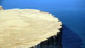
Closeup of the cliffs

Northeastern tip of Prince Leopold Island, with Far Lake on the left

Prince Leopold Island
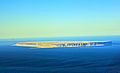
Full view of Prince Leopold Island


References[]
- ^ Jump up to: a b c Gaston, Anthony (March 2014). "Birds and Mammals of Prince Leopold Island, Nunavut, 1975 – 2012" (PDF). Arctic. 67 (1): 10–19. Retrieved 2021-09-06.
- ^ Parry, William (1821). Journal Of A Voyage For The Discovery Of A North-west Passage From The Atlantic To The Pacific. John Murray. p. 35. doi:10.5962/bhl.title.34367. ISBN 1175155721.
- ^ "Canada Elevation Map". maps.canada.ca. Retrieved 2021-09-06.
- ^ Latour, P.B.; Leger, J.; Hines, J.E.; Mallory, M.L.; Mulders, D.L.; Gilchrist, H.G.; Smith, P.A.; Dickson, D.L. (February 2008). Key migratory bird terrestrial habitat sites in the Northwest Territories and Nunavut (PDF) (Report). Canadian Wildlife Service. p. 56. Retrieved 2021-09-07.
- ^ "IBA Site Summary - Prince Leopold Island". www.ibacanada.org. Retrieved 2021-09-10.
- ^ "Prince Leopold Island Migratory Bird Sanctuary". www.canada.ca. 2019-11-14. Retrieved 2021-09-10.
External links[]
| Wikimedia Commons has media related to Prince Leopold Island. |
- Prince Leopold Island in the Atlas of Canada - Toporama; Natural Resources Canada
- Uninhabited islands of Qikiqtaaluk Region
- Islands of the Canadian Arctic Archipelago
- Important Bird Areas of Qikiqtaaluk Region
- Islands of Qikiqtaaluk Region