Princess Thyra Island
Prinsesse Thyra Ø | |
|---|---|
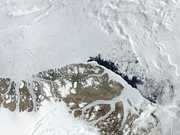 Satellite image of the northern end of Greenland including Princess Thyra Island | |
 Princess Thyra Island | |
| Geography | |
| Location | Wandel Sea |
| Coordinates | 81°57′N 21°15′W / 81.950°N 21.250°WCoordinates: 81°57′N 21°15′W / 81.950°N 21.250°W |
| Area | 295 km2 (114 sq mi) |
| Length | 36 km (22.4 mi) |
| Width | 8 km (5 mi) |
| Highest elevation | 76 m (249 ft) |
| Administration | |
| Zone | NE Greenland National Park |
| Demographics | |
| Population | 0 |

Princess Thyra Island (Danish: Prinsesse Thyra Ø) is an uninhabited island of the Wandel Sea, Greenland. The island is within King Frederick VIII Land in the Northeast Greenland National Park.[1] The island was named after Princess Thyra of Denmark.
Geography[]
This island is located east of Princess Margaret Island, to the northwest of Princess Dagmar Island close to the coast of far northeastern Greenland, in a bay of the Wandel Sea at the confluence of Denmark Sound and Independence Sound.[2]
The island has an area of 294.8 km ² and a shoreline of 85.7 kilometres.[3] It was formerly part of Avannaa, originally Nordgrønland ("North Greenland"), one of the counties of Greenland until 31 December 2008.
 Map of Far Northeastern Greenland. |
 1911 map of NE Greenland showing Princess Thyra Island, but not Princess Dagmar Island. |
See also[]
References[]
- ^ Compiled by Per Ivar Haug (August 2005). Ingar Lomheim (ed.). "Islands". Gazetteer of Greenland. UBiT, Universitetsbiblioteket i Trondheim "University Library in Trondheim" (15). ISBN 82-7113-114-1. ISSN 1502-0800. Archived from the original on 2011-06-15.
- ^ Prinsesse Thyra Ø
- ^ UNEP
This Greenland location article is a stub. You can help Wikipedia by . |
- Uninhabited islands of Greenland
- Greenland geography stubs