Pubarun
Pubarun
Khejuria | |
|---|---|
Populated place | |
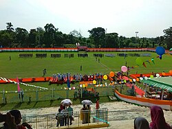 NTPC Stadium | |
 Pubarun Location in West Bengal, India | |
| Coordinates: 24°48′54″N 87°57′17″E / 24.81507°N 87.95482°ECoordinates: 24°48′54″N 87°57′17″E / 24.81507°N 87.95482°E | |
| Country | |
| State | West Bengal |
| District | Malda |
| Languages | |
| • Official | Bengali, English |
| Time zone | UTC+5:30 (IST) |
| PIN | 732315 |
| Telephone/ STD code | 03512 |
| Vehicle registration | WB |
| Lok Sabha constituency | Maldaha Dakshin |
| Vidhan Sabha constituency | Baisnabnagar |
| Website | malda |


Pubarun is a populated place, not identified as a separate place in 2011 census, in the Kaliachak III CD block in the Malda Sadar subdivision of Malda district in the state of West Bengal, India.
Geography[]
M: municipal town, CT: census town, R: rural/ urban centre, F: Facility, H: historical centre
Owing to space constraints in the small map, the actual locations in a larger map may vary slightly
Location[]
Pubarun is located at 24°48′54″N 87°57′17″E / 24.81507°N 87.95482°E.
Area overview[]
The area shown in the adjoining map is the physiographic sub-region known as the diara. It “is a relatively well drained flat land formed by the fluvial deposition of newer alluvium.” The most note-worthy feature is the Farakka Barrage across the Ganges.[1]The area is a part of the Malda Sadar subdivision, which is an overwhelmingly rural region, but the area shown in the map has pockets of urbanization with 17 census towns, concentrated mostly in the Kaliachak I CD block.[2][3]The bank of the Ganges between Bhutni and Panchanandapur (both the places are marked on the map), is the area worst hit by left bank erosion, a major problem in the Malda area.[4]The ruins of Gauda, capital of several empires, is located in this area.[5]
Note: The map alongside presents some of the notable locations in the area. All places marked in the map are linked in the larger full screen map.
Education[]
South Malda College was established in 1995 at Pubarun. Affiliated with the University of Gour Banga, it offers honours courses in Arabic, Bengali, English, economics, education, geography, history, political science, sociology (all for arts), accountancy (commerce), and general courses in arts and commerce.[6][7]
Sports[]
Netaji Subhas Chandra Bose Stadium is located in the NTPC township in Malda.[8]
References[]
- ^ "District Census Handbook Maldah, Series 20, Part XII A" (PDF). Census of India 2011, Pages 13-15: Physiography. Directorate of Census Operations, West Bengal. Retrieved 9 November 2018.
- ^ "District Statistical Handbook 2014 Malda". Table 2.1 , 2.2, 2.4b. Department of Statistics and Programme Implementation, Government of West Bengal. Retrieved 9 November 2018.
- ^ "C.D. Block Wise Primary Census Abstract Data(PCA)". West Bengal – District-wise CD Blocks. Registrar General and Census Commissioner, India. Retrieved 9 November 2018.
- ^ Banerjee, Manisha. "A Report on the Impact of Farakka Barrage on the Human Fabric, November 1999" (PDF). The social impact of erosion, pp 13-14. South Asia Network On Dams, Rivers and People, New Delhi: 110 088 India. Archived from the original (PDF) on 8 August 2017. Retrieved 16 August 2021.
- ^ "District Human Development Report, Malda". pages 3-4: Malda in Historical Perspective. Department of Planning, Statistics and Programme Monitoring, Government of West Bengal. Retrieved 6 November 2018.
- ^ "South Malda College". College Dekho. Retrieved 14 August 2021.
- ^ "South Malda College". College Admission. Retrieved 14 August 2021.
- ^ "Stadiums in India named after Netaji Subhas Chandra Bose". Netaji Subhas Chandra Bose Statdium, Malda, West Bengal. The Bridge. Retrieved 14 August 2021.
Cities, towns and locations in Malda district, Malda division | ||||||
|---|---|---|---|---|---|---|
| Cities, municipal and census towns |
|  Divisions of West Bengal | ||||
| Locations other than cities and towns |
| |||||
| Neighbourhood | ||||||
| Related topics |
| |||||
- Villages in Malda district