Puerto Rico Highway 503
  | ||||
|---|---|---|---|---|
| Ruta 503 | ||||
| Carretera David Medina Feliciano | ||||
 Map of Puerto Rico road PR-503 within the Municipality of Ponce in relation to the other major roads in the municipality | ||||
| Route information | ||||
| Maintained by Puerto Rico DTPW | ||||
| Length | 17.0 km[1][2] (10.6 mi) | |||
| Southern segment | ||||
| South end | Calle Salsa in Sexto | |||
| Major intersections | ||||
| North end | Portugués Dam in Tibes | |||
| Northern segment | ||||
| South end | ||||
| Major intersections | ||||
| North end | ||||
| Location | ||||
| Municipalities | Ponce, Utuado | |||
| Highway system | ||||
| ||||
Puerto Rico Highway 503 (PR-503), also called Carretera Tibes (Road to Tibes),[3] is a tertiary[4] state[5] road that connects Barrio Consejo, in the southwestern part of the municipality of Utuado, to Barrio Tercero in the city of Ponce, and ending at Museo de la Historia de Ponce, one block east of the center of the city at Plaza Las Delicias.
Route description[]
The road's northern terminus is at its intersection with Puerto Rico Highway 143 in Utuado's barrio Consejo, about 1/4 mile north of Utuado's borderline with the municipality of Adjuntas. The road runs in a southerly fashion from its northern terminus at Barrio Consejo, Utuado, through barrio Portugués of the municipality of Adjuntas, and then enters the municipality of Ponce, running through barrios Guaraguao, San Patricio, and Tibes. Starting in 2008, the flow of this road through Barrio Tibes was interrupted by the construction of the Rio Portugués river dam. As a result, there is now a permanent 3-mile stretch of this road that no longer exists. The road picks up again at the southern end of the Rio Portugues river dam, continuing in its southerly run through the rest of barrio Tibes and then through barrios Portugués Rural, and Portugués Urbano of the municipality of Ponce, before reaching barrio Sexto (Cantera) in the city of Ponce. The road then follows the course of Calle Mayor Cantera street in Ponce until it comes to its southern terminus at Calle Mayor street's intersection with Calle Isabel, (Calle Isabel is signed as PR-1).

Calle Mayor Cantera, part of PR-503 and near its southern terminus, in Ponce

A stretch of Puerto Rico Highway 503 (PR-503) heading northbound in Barrio Portugués Rural, in Ponce, Puerto Rico
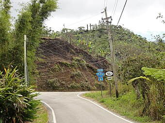
PR-503 southbound where PR-505 has its northern terminus, in Barrio San Patricio


Portugués dam[]
PR-503 used to be a single stretch country road from Ponce to Utuado until the late 2000s when construction of the Portugués Dam changed that.[6] In the mid 2010s a segment of this roadway was obliterated by the construction of the Portugués River reservoir, which now sits between the northern section of the road and the southern segment, disrupting the continuity of the road, but providing two approaches to the Dam and access to it from both the north and the south.
Road renamed[]
On 12 July 2011, Governor Luis Fortuño signed Law #130-2011 (House Bill 2885) naming this road as the David Medina-Feliciano Highway in honor of the costumbrista painter from Ponce.[6]
Major intersections[]
| Municipality | Location | km[1][2] | mi | Destinations | Notes | ||
|---|---|---|---|---|---|---|---|
| Ponce | Sexto | 0.0 | 0.0 | – Ponce | Southern terminus of PR-503 | ||
| Portugués | 1.4– 1.7 | 0.87– 1.1 | Partial cloverleaf interchange | ||||
| Tibes | 3.4 | 2.1 | |||||
| 5.5 | 3.4 | [[Puerto Rico Highway Portugués Dam |PR-Portugués Dam]] – Tibes | Northern terminus of southern segment; dead end road | ||||
| Gap in route | |||||||
| 0.0 | 0.0 | Southern terminus of northern segment | |||||
| San Patricio | 7.3 | 4.5 | |||||
| Utuado | Consejo | 11.5 | 7.1 | Northern terminus of PR-503 | |||
| 1.000 mi = 1.609 km; 1.000 km = 0.621 mi | |||||||
See also[]
- List of highways in Ponce, Puerto Rico
- List of highways numbered 503
- List of streets in Ponce, Puerto Rico
References[]
- ^ a b Google (1 March 2020). "PR-503 south" (Map). Google Maps. Google. Retrieved 1 March 2020.
- ^ a b Google (1 March 2020). "PR-503 north" (Map). Google Maps. Google. Retrieved 1 March 2020.
- ^ Acme Map for the Barrio Portugues area. ACME Mapper 2.1. ACME Labs. Accessed 3 February 2018.
- ^ PRHTA Design Manual: Chapter 1, General Design Criteria. Departamento de Transportación y Obras Publicas de Puerto Rico. page 1-2. Accessed 9 May 2019.
- ^ ¿Una avenida o zona de combate? Primera Hora. 19 June 2014. Retrieved 24 June 2014.
- ^ a b An ACT to designate PR Road 503, which extends from Ponce to Adjuntas as the David Medina-Feliciano Road. H.B. 2885. Oficina de Servicios Legislativos de Puerto Rico. Gobierno de Puerto Rico. Approved 12 July 2011. Published (English version) 30 September 2014. Accessed 8 April 2016.
External links[]
 Media related to Puerto Rico Highway 503 at Wikimedia Commons
- Guía de Carreteras Principales, Expresos y Autopistas (in Spanish)
- Highways in Puerto Rico