Puig Major
| Puig Major | |
|---|---|
 Puig Major | |
| Highest point | |
| Elevation | 1,436 m (4,711 ft) |
| Prominence | 1,436 m (4,711 ft) |
| Coordinates | 39°48′N 2°48′E / 39.800°N 2.800°ECoordinates: 39°48′N 2°48′E / 39.800°N 2.800°E |
| Geography | |
 Puig Major Majorca, Spain | |
| Parent range | Serra de Tramuntana |

Puig Major is the highest peak on the Spanish island of Majorca. With an elevation of 1,436 m (4,711 ft) above sea level. It is situated in the Serra de Tramuntana mountains. As the mountain is located in a military zone, the neighbouring peak Puig de Massanella (1,364 m) is considered the highest accessible summit on the island.
Gallery[]
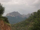
Puig Major
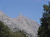
Radar station on Puig Major

Puig Major seen from a plane
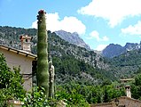
Puig Major (immediately to the right of the cactus) seen from the village of Fornalutx (near Soller)
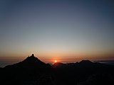
Dawn on the Penyal des Migdia with view of Puig Major and the air force installations


| Wikimedia Commons has media related to Puig Major. |
This article about a location in the Balearic Islands is a stub. You can help Wikipedia by . |
Categories:
- Mountains of Mallorca
- Mountains of the Balearic Islands
- Balearic Islands geography stubs