Pyllini
Pyllini
Πυλλήνη | |
|---|---|
 Pyllini Location within the regional unit 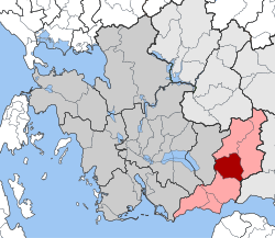 | |
| Coordinates: 38°32′N 21°49′E / 38.533°N 21.817°ECoordinates: 38°32′N 21°49′E / 38.533°N 21.817°E | |
| Country | Greece |
| Administrative region | West Greece |
| Regional unit | Aetolia-Acarnania |
| Municipality | Nafpaktia |
| • Municipal unit | 124.0 km2 (47.9 sq mi) |
| Population (2011)[1] | |
| • Municipal unit | 857 |
| • Municipal unit density | 6.9/km2 (18/sq mi) |
| Time zone | UTC+2 (EET) |
| • Summer (DST) | UTC+3 (EEST) |

Pyllini (Greek: Πυλλήνη or Πυλήνη) is a former municipality in Aetolia-Acarnania, West Greece, Greece. Since the 2011 local government reform it is part of the municipality Nafpaktia, of which it is a municipal unit.[2] The municipal unit has an area of 123.966 km2.[3] Population 857 (2011). The seat of the municipality was in Simos.
Subdivisions[]
The municipal unit Pyllini is subdivided into the following communities (constituent villages in brackets):
- Famila (Platanias, Sykea, Famila)
- Anthofyto (Anthofyto, Leptokarya)
- Gavros (Gavros, Koutsogiannaiika)
- Dorvitsa
- Eleftheriani
- Milea
- Palaiopyrgos (Palaiopyrgos, Perivolia)
- Pokista
- Simos (Simos, Kampos, Palaiochori)
- Stranoma (Stranoma, Ano Kampos, Kato Kampos, Loutra Stachtis)
- Stylia (Stylia, Agia Tiada)
References[]
- ^ a b "Απογραφή Πληθυσμού - Κατοικιών 2011. ΜΟΝΙΜΟΣ Πληθυσμός" (in Greek). Hellenic Statistical Authority.
- ^ "ΦΕΚ B 1292/2010, Kallikratis reform municipalities" (in Greek). Government Gazette.
- ^ "Population & housing census 2001 (incl. area and average elevation)" (PDF) (in Greek). National Statistical Service of Greece.
This Western Greece location article is a stub. You can help Wikipedia by . |
Categories:
- Populated places in Aetolia-Acarnania
- Nafpaktia
- Western Greece geography stubs