Quanah, Texas
Quanah, Texas | |
|---|---|
City | |
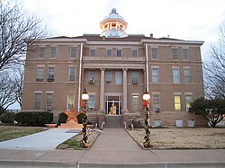 Hardeman County Courthouse in 2006 | |
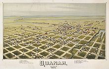
 Location of Quanah, Texas | |
 | |
| Coordinates: 34°17′44″N 99°44′31″W / 34.29556°N 99.74194°WCoordinates: 34°17′44″N 99°44′31″W / 34.29556°N 99.74194°W | |
| Country | United States |
| State | Texas |
| County | Hardeman |
| Government | |
| • Mayor | Dale Eaton |
| Area | |
| • Total | 3.48 sq mi (9.00 km2) |
| • Land | 3.48 sq mi (9.00 km2) |
| • Water | 0.00 sq mi (0.00 km2) |
| Elevation | 1,572 ft (479 m) |
| Population (2010) | |
| • Total | 2,641 |
| • Estimate (2019)[2] | 2,487 |
| • Density | 715.48/sq mi (276.23/km2) |
| Time zone | UTC-6 (Central (CST)) |
| • Summer (DST) | UTC-5 (CDT) |
| ZIP code | 79252 |
| Area code(s) | 940 |
| FIPS code | 48-60044[3] |
| GNIS feature ID | 1365885[4] |
| Website | www |

Quanah /ˈkwɑːnə/ is a city in and the county seat of Hardeman County, Texas, United States.[5] As of the 2010 census the population was 2,641,[6] down from 3,022 at the 2000 census.
Quanah is 192 miles (309 km) northwest of Fort Worth and 8 miles (13 km) south of the Red River, which forms the Oklahoma-Texas state line. Copper Breaks State Park is 12 miles (19 km) south of the city.
History[]
Quanah was organized in 1884 as a stop on what was then the Fort Worth and Denver City Railway. The city was named for Quanah Parker, the last Comanche chief.
The county seat of Hardeman County was moved from Margaret to Quanah in 1890 after an acrimonious battle that contributed to the splitting off of the southern section of Hardeman County as Foard County.[7] The courthouse, constructed in 1908, anchors what is now the historic downtown district. The courthouse was financed by a bond election approved by voters in 1906. The project architect was R.H. Stuckey of Chillicothe, Texas. It has a domed cupola and Ionic columns.[8]
Geography[]
Quanah is at the geographic center of Hardeman County, at the intersection of U.S. Route 287 (11th Street) and Texas State Highway 6 (Main Street). US 287 leads southeast 30 miles (48 km) to Vernon and northwest 28 miles (45 km) to Childress. Highway 6 leads south 21 miles (34 km) to Crowell and north 8 miles (13 km) to the Oklahoma border at the Red River. Altus, Oklahoma, is 40 miles (64 km) northeast of Quanah via Oklahoma Highway 6.
According to the United States Census Bureau, Quanah has a total area of 3.5 square miles (9.0 km2), all of it land.[6]
Climate[]
| Climate data for Quanah, Texas | |||||||||||||
|---|---|---|---|---|---|---|---|---|---|---|---|---|---|
| Month | Jan | Feb | Mar | Apr | May | Jun | Jul | Aug | Sep | Oct | Nov | Dec | Year |
| Average high °F (°C) | 54 (12) |
58 (14) |
67 (19) |
76 (24) |
84 (29) |
94 (34) |
98 (37) |
98 (37) |
90 (32) |
79 (26) |
65 (18) |
55 (13) |
77 (25) |
| Average low °F (°C) | 28 (−2) |
31 (−1) |
38 (3) |
48 (9) |
54 (12) |
67 (19) |
71 (22) |
71 (22) |
63 (17) |
51 (11) |
38 (3) |
30 (−1) |
49 (10) |
| Average precipitation inches (mm) | 0.7 (18) |
0.9 (23) |
1.4 (36) |
2.6 (66) |
3.6 (91) |
3.4 (86) |
2.1 (53) |
2.2 (56) |
2.7 (69) |
2.8 (71) |
1.1 (28) |
1.2 (30) |
24.6 (620) |
| Source: Weatherbase [9] | |||||||||||||
Demographics[]
| Historical population | |||
|---|---|---|---|
| Census | Pop. | %± | |
| 1890 | 1,477 | — | |
| 1900 | 1,651 | 11.8% | |
| 1910 | 3,127 | 89.4% | |
| 1920 | 3,691 | 18.0% | |
| 1930 | 4,464 | 20.9% | |
| 1940 | 3,767 | −15.6% | |
| 1950 | 4,589 | 21.8% | |
| 1960 | 4,564 | −0.5% | |
| 1970 | 3,948 | −13.5% | |
| 1980 | 3,890 | −1.5% | |
| 1990 | 3,413 | −12.3% | |
| 2000 | 3,022 | −11.5% | |
| 2010 | 2,641 | −12.6% | |
| 2019 (est.) | 2,487 | [2] | −5.8% |
| U.S. Decennial Census[10] | |||


As of the census[3] of 2000, there were 3,022 people, 1,255 households, and 823 families residing in the city. Now in 2010 the United States Census as said there are 2,642 people, a drop in population of 390 people. The population density was 866.8 people per square mile (334.3/km2). There were 1,485 housing units at an average density of 425.9 per square mile (164.3/km2). The racial makeup of the city was 84.05% White, 4.96% African American, 0.40% Native American, 0.43% Asian, 8.24% from other races, and 1.92% from two or more races. Hispanic or Latino of any race were 16.48% of the population.
There were 1,255 households, out of which 29.2% had children under the age of 18 living with them, 51.8% were married couples living together, 10.4% had a female householder with no husband present, and 34.4% were non-families. 31.9% of all households were made up of individuals, and 20.2% had someone living alone who was 65 years of age or older. The average household size was 2.35 and the average family size was 2.96.
In the city, the population was spread out, with 25.1% under the age of 18, 7.9% from 18 to 24, 22.0% from 25 to 44, 22.9% from 45 to 64, and 22.0% who were 65 years of age or older. The median age was 42 years. For every 100 females, there were 87.6 males. For every 100 females age 18 and over, there were 83.2 males.
The median income for a household in the city was $26,354, and the median income for a family was $29,506. Males had a median income of $26,472 versus $18,403 for females. The per capita income for the city was $16,841. About 16.6% of families and 20.7% of the population were below the poverty line, including 29.8% of those under age 18 and 16.4% of those age 65 or over.
Government[]
Republican Drew Springer, Jr., a businessman from Muenster in Cooke County, has represented Quanah in the Texas House of Representatives since January 2013.[11]
Education[]
The city is served by the Quanah Independent School District and is home to the Quanah High School Indians.
Infrastructure[]
Health care[]
Quanah is home to a branch of the Mental Health Centers.
Notable people[]
- Judy Buenoano, serial killer executed in Florida's electric chair.[12]
- Bill Evans, awarded a Bronze Star and Silver Star for valor in World War II; professional baseball player in late 1940s and 1950s.[13]
- Welborn Griffith, American officer who served during World War II and who was instrumental in saving France's Chartres Cathedral during the battle of Chartres.[14]
- John Gilliland, radio broadcaster.[15]
- Edward Givens, astronaut.[16]
- Fred C. Koch, chemical engineer and founder of Koch Industries.[17]
- , notable Texas Ranger.[18]
- Juli Reding, actress
- Clay Reynolds, Texas author and essayist.
- Bruce F. Cook. Cousin of Edward Givens. Former director of the Clemson University Tiger Band and founding member of the Brooks Center for the Performing Arts at Clemson University.
References[]
- ^ "2019 U.S. Gazetteer Files". United States Census Bureau. Retrieved August 7, 2020.
- ^ a b "Population and Housing Unit Estimates". United States Census Bureau. May 24, 2020. Retrieved May 27, 2020.
- ^ a b "U.S. Census website". United States Census Bureau. Retrieved 2008-01-31.
- ^ "US Board on Geographic Names". United States Geological Survey. 2007-10-25. Retrieved 2008-01-31.
- ^ "Find a County". National Association of Counties. Archived from the original on May 31, 2011. Retrieved 2011-06-07.
- ^ a b "Geographic Identifiers: 2010 Census Summary File 1 (G001): Quanah city, Texas". American Factfinder. U.S. Census Bureau. Archived from the original on February 13, 2020. Retrieved February 2, 2018.
- ^ Bill Neal, The Last Frontier: A History of Hardeman County. Austin: Eakin Press, 1996, p. 50
- ^ Historical marker, Hardeman County Courthouse, Quanah, Texas
- ^ "Weatherbase: Historical Weather for Quanah, Texas". Weatherbase. 2011. Retrieved on November 24, 2011.
- ^ "Census of Population and Housing". Census.gov. Retrieved June 4, 2015.
- ^ "State Rep. Springer announces district tour July 30". Lubbock Avalanche-Journal, July 16, 2013. Retrieved July 18, 2013.
- ^ "Judias V. Buenoano". Office of the Clark County Prosecuting Attorney. Retrieved Nov 2013.
{{cite web}}: Check date values in:|access-date=(help) - ^ "Bill Evans". Baseball in Wartime. January 6, 2008.
- ^ "Valor awards for Welborn Barton Griffith, Jr". valor.militarytimes.com. Retrieved 2017-05-25.
- ^ "About John Gilliland". University of north Texas Digital Library. Retrieved Nov 2013.
{{cite web}}: Check date values in:|access-date=(help) - ^ "Biographical Data". NASA. June 1967.
- ^ "Fred C. Koch". Fred and Mary Koch Foundation. Archived from the original on 2013-11-14. Retrieved Nov 2013.
{{cite web}}: Check date values in:|access-date=(help) - ^ "Quanah, Texas". Texas Escapes. May 7, 2010.
External links[]
| Wikivoyage has a travel guide for Quanah. |
Municipalities and communities of Hardeman County, Texas, United States | ||
|---|---|---|
| Cities |  | |
| Ghost town | ||
| ||
Austin (capital) | ||
| Topics |
| |
| Society |
| |
| Regions |
| |
| Metropolitan areas |
| |
| Counties | ||

- Cities in Hardeman County, Texas
- Cities in Texas
- County seats in Texas
- 1884 establishments in Texas