Quatre
This article needs additional citations for verification. (January 2021) |
Native name: Isle à Quatre | |||||||||||
|---|---|---|---|---|---|---|---|---|---|---|---|
 View S-W from Bequia island. Isle Quatre is on the horizon in the left side of the picture. | |||||||||||
 Quatre | |||||||||||
| Geography | |||||||||||
| Location | Caribbean | ||||||||||
| Coordinates | 12°57′15.4″N 61°15′09.5″W / 12.954278°N 61.252639°WCoordinates: 12°57′15.4″N 61°15′09.5″W / 12.954278°N 61.252639°W | ||||||||||
| Archipelago | Grenadines | ||||||||||
| Area | 1.52 km2 (0.59 sq mi) | ||||||||||
| Highest elevation | 146 m (479 ft) | ||||||||||
| Administration | |||||||||||
| Additional information | |||||||||||
| Time zone |
| ||||||||||
Private island[1]
| |||||||||||


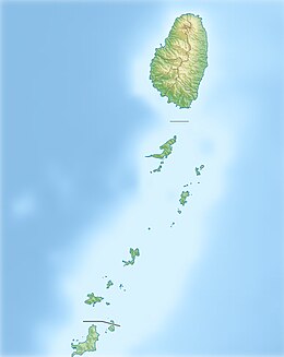
Quatre is one of the Grenadines islands which lie between the Caribbean islands of Saint Vincent and Grenada. It is part of the nation of Saint Vincent and the Grenadines.
Geography[]
Quatre island lies southwest of Pigeon Island and south of the larger islands Bequia and Canouan. About 8 km away, to the southeast is popular with tourists island Mustique. It has an area of 1.52 km² and a length of 3 km and a width of 250 to 950 m. The highest point reaches 146 m above sea level, and the average height is 38 meters.
History[]
Until the end of Seven Years' War Quatre island was France colony along with the other islands of this region. In 1763 they all were ceded to England. For more than a hundred years, the island has been owned by the Mitchell family, former captains who will continue to keep a part of the island for themselves after sale of big part of island for resort development.
The island was formerly home to white cedar (Tabebuia heterophylla), which was used for shipbuilding.
References[]
This Saint Vincent and the Grenadines location article is a stub. You can help Wikipedia by . |
- IUCN Category IV
- Islands of Saint Vincent and the Grenadines
- Windward Islands
- Private islands of Saint Vincent and the Grenadines
- Saint Vincent and the Grenadines geography stubs