Quinton (CDP), New Jersey
Quinton, New Jersey | |
|---|---|
 Quinton Township highlighted in Salem County. Inset map: Salem County highlighted in the State of New Jersey. | |
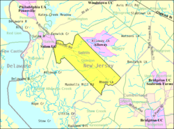 Census Bureau map of Quinton Township, New Jersey | |
 Quinton, New Jersey Quinton CDP's location within Quinton Township in Salem County. | |
| Coordinates: 39°32′51″N 75°24′39″W / 39.547478°N 75.410915°WCoordinates: 39°32′51″N 75°24′39″W / 39.547478°N 75.410915°W[1][2] | |
| Country | |
| State | |
| County | Salem |
| Township | Quinton |
| Area | |
| • Total | 0.908 sq mi (2.354 km2) |
| • Land | 0.885 sq mi (2.293 km2) |
| • Water | 0.023 sq mi (0.061 km2) 2.57% |
| Elevation | 23 ft (7 m) |
| Population | |
| • Total | 588 |
| • Density | 664.1/sq mi (256.4/km2) |
| Time zone | UTC-5 (Eastern (EST)) |
| • Summer (DST) | UTC-4 (Eastern (EDT)) |
| ZIP code | 08072[5] |
| Area code(s) | 856 |
| FIPS code | 3461440[1][6] |
| GNIS feature ID | 02584021[1][7] |


Quinton is an unincorporated community and census-designated place (CDP) located within Quinton Township, in Salem County, New Jersey, United States.[8][9][10][11] As of the 2010 United States Census, the CDP's population was 1,402.[4]
Quinton CDP and Quinton Township are not coextensive, with the CDP covering 3.7% of the 24.588 miles (39.571 km) of the township as a whole.[8]
Geography[]
According to the United States Census Bureau, Quinton CDP had a total area of 0.908 square miles (2.354 km2), including 0.885 square miles (2.293 km2) of land and 0.023 square miles (0.061 km2) of water (2.57%).[1][2]
Demographics[]
Census 2010[]
The 2010 United States census counted 588 people, 215 households, and 163 families in the CDP. The population density was 664.1 per square mile (256.4/km2). There were 225 housing units at an average density of 254.1 per square mile (98.1/km2). The racial makeup was 86.05% (506) White, 6.97% (41) Black or African American, 0.85% (5) Native American, 0.34% (2) Asian, 0.00% (0) Pacific Islander, 0.34% (2) from other races, and 5.44% (32) from two or more races. Hispanic or Latino of any race were 3.06% (18) of the population.[4]
Of the 215 households, 36.3% had children under the age of 18; 54.0% were married couples living together; 14.4% had a female householder with no husband present and 24.2% were non-families. Of all households, 18.6% were made up of individuals and 7.0% had someone living alone who was 65 years of age or older. The average household size was 2.73 and the average family size was 3.12.[4]
28.7% of the population were under the age of 18, 5.6% from 18 to 24, 26.5% from 25 to 44, 24.8% from 45 to 64, and 14.3% who were 65 years of age or older. The median age was 37.1 years. For every 100 females, the population had 100.0 males. For every 100 females ages 18 and older there were 94.0 males.[4]
References[]
- ^ a b c d e Gazetteer of New Jersey Places, United States Census Bureau. Accessed July 21, 2016.
- ^ a b US Gazetteer files: 2010, 2000, and 1990, United States Census Bureau. Accessed September 4, 2014.
- ^ U.S. Geological Survey Geographic Names Information System: Quinton Census Designated Place, Geographic Names Information System. Accessed February 10, 2013.
- ^ a b c d e DP-1 - Profile of General Population and Housing Characteristics: 2010 Demographic Profile Data for Quinton CDP, New Jersey, United States Census Bureau. Accessed February 10, 2013.
- ^ Look Up a ZIP Code for Quinton, NJ, United States Postal Service. Accessed February 10, 2013.
- ^ U.S. Census website, United States Census Bureau. Accessed September 4, 2014.
- ^ US Board on Geographic Names, United States Geological Survey. Accessed September 4, 2014.
- ^ a b GCT-PH1 - Population, Housing Units, Area, and Density: 2010 - County -- County Subdivision and Place from the 2010 Census Summary File 1 for Salem County, New Jersey Archived 2020-02-12 at archive.today, United States Census Bureau. Accessed February 10, 2013.
- ^ 2006-2010 American Community Survey Geography for New Jersey, United States Census Bureau. Accessed February 10, 2013.
- ^ New Jersey: 2010 - Population and Housing Unit Counts - 2010 Census of Population and Housing (CPH-2-32), United States Census Bureau, August 2012. Accessed February 10, 2013.
- ^ Locality Search, State of New Jersey. Accessed April 19, 2015.
Municipalities and communities of Salem County, New Jersey, United States | ||
|---|---|---|
| City |  | |
| Boroughs | ||
| Townships | ||
| CDPs | ||
| Other unincorporated communities | ||
| ||
- Census-designated places in Salem County, New Jersey
- Quinton Township, New Jersey