Quito Glacier
From Wikipedia, the free encyclopedia
Glacier in Antarctica
| Quito Glacier | |
|---|---|
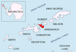 Location of Greenwich Island in the South Shetland Islands | |
 Location of Quito Glacier in Antarctica  Quito Glacier (Antarctica) | |
| Location | Greenwich Island South Shetland Islands |
| Coordinates |  62°27′00″S 59°47′00″W / 62.45000°S 59.78333°W / -62.45000; -59.78333 62°27′00″S 59°47′00″W / 62.45000°S 59.78333°W / -62.45000; -59.78333 |
| Thickness | unknown |
| Terminus | Canto Point |
| Status | unknown |
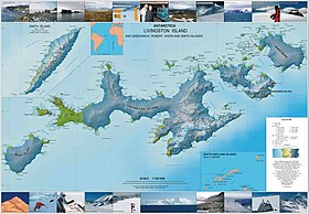
Topographic map of Livingston Island, Greenwich, Robert, Snow and Smith Islands.
Quito Glacier (62°27′S 59°47′W / 62.450°S 59.783°W / -62.450; -59.783Coordinates: WikiMiniAtlas62°27′S 59°47′W / 62.450°S 59.783°W / -62.450; -59.783) is a glacier draining the northeast slopes of Mount Plymouth and flowing northeastwards into the sea west of Canto Point in north Greenwich Island, South Shetland Islands. It was named after the capital of Ecuador, c. 1990, by the .
Contents
See also[]
- List of glaciers in the Antarctic
- Glaciology
Maps[]
- L.L. Ivanov et al. Antarctica: Livingston Island and Greenwich Island, South Shetland Islands. Scale 1:100000 topographic map. Sofia: Antarctic Place-names Commission of Bulgaria, 2005.
- L.L. Ivanov. Antarctica: Livingston Island and Greenwich, Robert, Snow and Smith Islands. Scale 1:120000 topographic map. Troyan: Manfred Wörner Foundation, 2009. ISBN 978-954-92032-6-4
References[]
 This article incorporates public domain material from the United States Geological Survey document: "Quito Glacier". (content from the Geographic Names Information System)
External links[]
Portal: Geography
Glaciers | |||||||
|---|---|---|---|---|---|---|---|
| Types |
| ||||||
| Anatomy |
| ||||||
| Processes |
| ||||||
| Measurements |
| ||||||
| Volcanic relations | |||||||
| Landforms |
| ||||||
| |||||||
Glaciers in the Antarctic | |
|---|---|
|
Glaciers of South Shetland Islands | |
|---|---|
| Clarence Island | |
| Elephant Island |
|
| Greenwich Island | |
| King George Island |
|
| Livingston Island |
|
| Smith Island | |
This article about a glacier in Greenwich Island is a stub. You can help Wikipedia by . |
- v
- t
Retrieved from ""
Categories:
- Glaciers of Greenwich Island
- South Shetland Islands glacier stubs
- Greenwich Island geography stubs
Hidden categories:
- Articles with short description
- Short description matches Wikidata
- Coordinates on Wikidata
- Wikipedia articles incorporating text from the USGS Geographic Names Information System
- All stub articles