Bokhtar
Bokhtar
Tajik: Бохтар | |
|---|---|
 Bokhtar in 2018 | |
 Bokhtar Location in Tajikistan | |
| Coordinates: 37°50′11″N 68°46′49″E / 37.83639°N 68.78028°ECoordinates: 37°50′11″N 68°46′49″E / 37.83639°N 68.78028°E | |
| Country | |
| Province | Khatlon |
| Area | |
| • City | 26 km2 (10 sq mi) |
| Elevation | 430 m (1,410 ft) |
| Population (2019) | |
| • City | 110 800 |
| • Density | 4,261/km2 (11,040/sq mi) |
| • Metro | 190 000 |
| Area code(s) | 992-3222 |
| Official languages | |

Bokhtar (Tajik: Бохтар),[2] previously known as Qurghonteppa or Kurganteppa, is a city in southwestern Tajikistan, which serves as the capital of the Khatlon region. Bokhtar is the largest city of southern Tajikistan, and is located 100 kilometres (62 mi) south of Dushanbe and 150 kilometres (93 mi) north of Kunduz, Afghanistan.
Population[]
It is estimated that the population of the city is close to 110,800 (est. 2019) people, making it the third-largest city in the country. The population fluctuates depending on season (due to Tajik immigrant workers in Russia).
Along with the capital Dushanbe, Bokhtar is demographically much more diverse than other major Tajik cities such as Khujand, Kulob or Istaravshan.[3] Ethnicities include Tajiks, Uzbeks, Russians, Pashtuns, Tatars, Ukrainians, Kazakhs, Greeks and many more.[citation needed] The city had a large number of ethnic Russians who were actively employed by the industrial and agricultural complexes in and around the city.
The political opposition in Tajikistan primarily comes from Bokhtar.[4]
Overview[]
Bokhtar, then Qurghonteppa, became the epicenter of conflict by the summer of 1992 and was seriously damaged during the civil war.[5] Many of the local Kulobi and Uzbeks were forced to flee in 1992 following advances and attacks from the pro-opposition Gharmi forces.[6]
12 km east of the Tube, there stands a hill called Ajina tepe with a 12-metre-length image of Buddha in Nirvana, including remnants of a Buddhist Monastery from the 7th - 8th cent.[7]
Bokhtar International Airport serves a handful of cities in Tajikistan, Russia and Kazakhstan. The city is considered to be the heart of cotton ("white gold") cultivation in Tajikistan.[citation needed]
Bokhtar and Kulob are the main cities of south Tajikistan. Bokhtar is a regional hub (one of the top four), especially for banking and telecommunications industries.[citation needed]
The city was officially renamed on January 22, 2018 to "Bokhtar".[8]
Tajik immigrant workers (mostly employed in Russia) have significantly contributed to the local economy since early 2000s.[citation needed]

Indian Prime Minister Narendra Modi and President of Tajikistan Emomali Rahmon with personnel of the India-Tajik Friendship Hospital in Bokhtar, 13 July 2015.

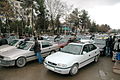
Bokhtar Bazaar
Busy street in Bokhtar


Climate[]
Bokhtar has a semi-arid climate (Köppen climate classification BSk), with cool winters and very hot summers. Precipitation is quite low, and peaks in spring, while summers are very dry.
| hideClimate data for Bokhtar | |||||||||||||
|---|---|---|---|---|---|---|---|---|---|---|---|---|---|
| Month | Jan | Feb | Mar | Apr | May | Jun | Jul | Aug | Sep | Oct | Nov | Dec | Year |
| Record high °C (°F) | 22.1 (71.8) |
27.9 (82.2) |
33.4 (92.1) |
36.7 (98.1) |
41.3 (106.3) |
43.6 (110.5) |
46.0 (114.8) |
42.8 (109.0) |
38.6 (101.5) |
36.1 (97.0) |
30.5 (86.9) |
24.3 (75.7) |
46.0 (114.8) |
| Average high °C (°F) | 8.1 (46.6) |
11.7 (53.1) |
17.2 (63.0) |
24.2 (75.6) |
30.4 (86.7) |
35.8 (96.4) |
37.3 (99.1) |
35.5 (95.9) |
31.2 (88.2) |
25.1 (77.2) |
17.6 (63.7) |
10.6 (51.1) |
23.7 (74.7) |
| Daily mean °C (°F) | 2.5 (36.5) |
5.4 (41.7) |
10.8 (51.4) |
17.2 (63.0) |
22.7 (72.9) |
27.3 (81.1) |
28.7 (83.7) |
26.4 (79.5) |
21.1 (70.0) |
15.2 (59.4) |
9.1 (48.4) |
4.4 (39.9) |
15.9 (60.6) |
| Average low °C (°F) | −1.5 (29.3) |
1.0 (33.8) |
5.9 (42.6) |
11.2 (52.2) |
15.3 (59.5) |
18.1 (64.6) |
19.3 (66.7) |
17.1 (62.8) |
12.1 (53.8) |
7.6 (45.7) |
3.2 (37.8) |
0.3 (32.5) |
9.1 (48.4) |
| Record low °C (°F) | −24.1 (−11.4) |
−22.6 (−8.7) |
−12.7 (9.1) |
−1.8 (28.8) |
4.0 (39.2) |
9.1 (48.4) |
11.0 (51.8) |
9.4 (48.9) |
3.5 (38.3) |
−4.2 (24.4) |
−10.9 (12.4) |
−20.0 (−4.0) |
−24.1 (−11.4) |
| Average precipitation mm (inches) | 36.1 (1.42) |
39.6 (1.56) |
61.0 (2.40) |
39.6 (1.56) |
24.1 (0.95) |
3.2 (0.13) |
0.3 (0.01) |
0.1 (0.00) |
0.8 (0.03) |
8.8 (0.35) |
19.3 (0.76) |
29.8 (1.17) |
262.7 (10.34) |
| Average precipitation days (≥ 0.1 mm) | 8.2 | 11.2 | 7.0 | 5.9 | 2.7 | 0.2 | 1.0 | 0.8 | 1.3 | 3.7 | 6.4 | 7.3 | 55.7 |
| Average relative humidity (%) | 73.2 | 70.1 | 62.3 | 57.6 | 50.2 | 45.5 | 45.6 | 48.3 | 51.0 | 57.1 | 66.6 | 73.0 | 58.4 |
| Mean monthly sunshine hours | 112 | 125 | 164 | 213 | 291 | 339 | 351 | 334 | 294 | 235 | 174 | 115 | 2,747 |
| Source 1: climatebase.ru[9] | |||||||||||||
| Source 2: NOAA (sun only, 1961-1990)[10] | |||||||||||||
Notable people[]
- Sergei Mandreko (1971-) - football coach
- Nurudin N. Mukhitdinov (1959-) - politician
Trivia[]
Finnish electronic duo Pan Sonic have a track entitled "Radio Qurghonteppa" on their 2010 farewell album Gravitoni.[11]
See also[]
- List of cities in Tajikistan
- FC Khatlon football club
- Buddhistic cloister of Ajina-Tepa
References[]
- ^ "КОНСТИТУЦИЯ РЕСПУБЛИКИ ТАДЖИКИСТАН". prokuratura.tj. Parliament of Tajikistan. Retrieved 9 January 2020.
- ^ Переименование ряда городов, районов и селений Хатлонской области, Президент Республики Таджикистан
- ^ Borjian, Habib, “Kurgan Tepe”, Encyclopaedia Iranica. Online edition 2005. [1]
- ^ Ethnic groups at risk: The status of Tajiks Heritage Society
- ^ "Memories of the Tajik Civil War". CESMI. November 22, 2012.
- ^ Hays, Jeffrey. "HEART OF THE TAJIK CIVIL WAR IN 1992 | Facts and Details". factsanddetails.com.
- ^ "Kurgan Tube". Retrieved March 27, 2021.
- ^ "Renaming of a number of cities, districts and settlements of Khatlon Province | Президенти Тоҷикистон - President of Tajikistan - Президент Таджикистана - رئيس جمهورية تاجيكستان". prezident.tj.
- ^ "Kurgan-Tyube,Tajikistan". Climatebase.ru. Retrieved 31 January 2013.
- ^ "Climate Normals for Kurgan-Tjube". National Oceanic and Atmospheric Administration. Retrieved 31 January 2013.
- ^ "Pan Sonic - Gravitoni". Discogs.
External links[]
| Wikimedia Commons has media related to Bokhtar. |
- Kurgan Tepe in Encyclopaedia Iranica Online
| Rank | Name | Region | Pop. | ||||||
|---|---|---|---|---|---|---|---|---|---|
 Dushanbe 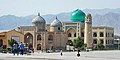 Khujand |
1 | Dushanbe | Dushanbe | 846,400 |  Bokhtar 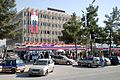 Kulob | ||||
| 2 | Khujand | Sughd | 181,600 | ||||||
| 3 | Bokhtar | Khatlon | 110,800 | ||||||
| 4 | Kulob | Khatlon | 105,500 | ||||||
| 5 | Istaravshan | Sughd | 64,600 | ||||||
| 6 | Isfara | Sughd | 59,500 | ||||||
| 7 | Vahdat | Districts of Republican Subordination | 55,000 | ||||||
| 8 | Tursunzoda | Districts of Republican Subordination | 53,700 | ||||||
| 9 | Konibodom | Sughd | 52,200 | ||||||
| 10 | Panjakent | Sughd | 42,800 | ||||||

- Populated places in Khatlon Region