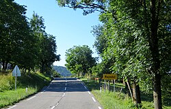
Rajndol
Rajndol | |
|---|---|
 | |
 Rajndol Location in Slovenia | |
| Coordinates: 45°34′4.11″N 14°56′50.83″E / 45.5678083°N 14.9474528°ECoordinates: 45°34′4.11″N 14°56′50.83″E / 45.5678083°N 14.9474528°E | |
| Country | |
| Traditional region | Lower Carniola |
| Statistical region | Southeast Slovenia |
| Municipality | Kočevje |
| Area | |
| • Total | 5.27 km2 (2.03 sq mi) |
| Elevation | 509.9 m (1,672.9 ft) |
| Population (2002) | |
| • Total | 45 |
| [1] | |
Rajndol (pronounced [ˈɾaːi̯ndɔl]; German: Reinthal[2] or Reintal[3]) is a small settlement in the Municipality of Kočevje in southern Slovenia. It was inhabited mostly by Gottschee Germans. During the Second World War its original population was expelled. The area is part of the traditional region of Lower Carniola and is now included in the Southeast Slovenia Statistical Region.[4]
A mid-18th-century chapel in the village was dedicated to the Guardian Angels and was demolished in the 1950s along with much of the ecclesiastical heritage of the Kočevje area.[5]
References[]
- ^ Statistical Office of the Republic of Slovenia
- ^ Leksikon občin kraljestev in dežel zastopanih v državnem zboru, vol. 6: Kranjsko. 1906. Vienna: C. Kr. Dvorna in Državna Tiskarna, p. 38.
- ^ Ferenc, Mitja. 2007. Nekdanji nemški jezikovni otok na kočevskem. Kočevje: Pokrajinski muzej, p. 4.
- ^ Kočevje municipal site
- ^ Slovenian Ministry of Culture register of national heritage reference number ešd 2801
External links[]
 Media related to Rajndol at Wikimedia Commons
- Rajndol on Geopedia
- Pre–World War II map of Rajndol with oeconyms and family names
Categories:
- Populated places in the Municipality of Kočevje
- Kočevje geography stubs

