Rajpora
Rajpora
Rajpur | |
|---|---|
Town | |
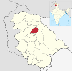 Pulwama District | |
| Administered by | India |
| Elevation | 1,800 m (5,905 ft) |
| Population | |
| • Total | 5,215[1] |
| Languages | |
| • Official | Kashmiri, Hindi, Urdu, Dogri, English[2][3] |
| Time zone | UTC+5:30 (IST) |
Rajpora, also known as Rajpur, is a town and a tehsil capital in the Pulwama district of Jammu and Kashmir. It is located 43 km away from Srinagar and 299 km away from Jammu. Rajpora is situated at 1,800 metres (5,900 ft) above the mean sea level.
Demographics[]
As per census of 2011 population of Rajpora stands at 5,215, with 2,756 males and 2,459 females.[1] Population of people under the age of 6 in Rajpora is 1,169, which is 22.42% of total population of the village. Average Sex Ratio of Rajpora village is 892 and child Sex Ratio of the Rajpora as per census of 2011 is 729. In 2011, literacy rate of Rajpora was 62% in which male literacy stands at 57.67% while female literacy rate stands at 51.61%.[1]
Governance[]
Under the Panchyati Raj Act, Rajpora is administered by the Sarpanch.[1]
Economy[]
Out of total population only 3,289 people were employed as of 2011 census.[1]
Education[]
- Government Degree College, Rajpora
- Govt Model Higher Secondary Rajpora
Castes[]
Schedule Tribe (ST) constitutes 0.29% of total population in Rajpora. No Scheduled Caste (SC) live in Rajpora.[1]
References[]
- ^ a b c d e f "Raj Pora Village Population - Pulwama - Pulwama, Jammu and Kashmir". www.census2011.co.in.
- ^ "The Jammu and Kashmir Official Languages Act, 2020" (PDF). The Gazette of India. 27 September 2020. Retrieved 27 September 2020.
- ^ "Parliament passes JK Official Languages Bill, 2020". Rising Kashmir. 23 September 2020. Retrieved 30 May 2021.
Coordinates: 33°49′27.35″N 74°51′11.29″E / 33.8242639°N 74.8531361°E

- Villages in Pulwama district
- History of the Republic of India
- States and territories established in 1947
- 1947 establishments in India
- Kashmiri-speaking countries and territories