Rancho, Aruba
Rancho | |
|---|---|
Neighbourhood | |
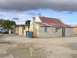 House in Rancho | |
 Rancho Location in Aruba | |
| Coordinates: 12°31′20″N 70°02′11″W / 12.5222°N 70.0363°WCoordinates: 12°31′20″N 70°02′11″W / 12.5222°N 70.0363°W | |
| State | Kingdom of the Netherlands |
| Country | Aruba |
| Region | Oranjestad West |
| Population (2010)[1] | |
| • Total | 1,540 |

Rancho is a former fishing village and neighbourhood of Oranjestad, Aruba. In the late 20th century, it was annexed by Oranjestad.[2]
History[]
Rancho was first mentioned in 1855 as a fishing village with small huts located in the vicinity of the Oranjestad[3][4] The village had a little harbour where ships used to anchor for Oranjestad. In 1928, Arend Petroleum Maatschappij, a subsidiary of Royal Dutch Shell, opened an oil refinery near Rancho[5] which resulted in a population increase and the construction of stone houses.[2]
Rancho and Oranjestad merged into a single urban area, and in the late 20th century it was annexed.[2] In order to preserve the village characteristics, buildings are limited to a height of five metres unless an exception is granted.[6] Rancho has become an impoverished part of the city.[7] On 20 April 2010, the Rancho Foundation was established to preserve the former fishing village.[3]
Overview[]

Rancho is home the only remaining lime kiln of Aruba. It was built in 1892 and had been in operation until 1949. It was restored in 1970, and has been declared a monument.[8]
In 1905, Hendrik Eman was given permission to lay pipes from the water wells in Saliña and Madiki to the harbour of Oranjestad. Excess water was stored in a water tank in Rancho, and sold to the inhabitants of the city.[9] In 2020, a program began to conserve the water tank as an early industrial heritage site.[10]
The National Archaeological Museum Aruba is located in Rancho,[11] and the tram has a stop in Rancho.[12]
Notable people[]
- Boy Ecury (1922–1944), World War II resistance fighter[13]
- Nydia Ecury (1926–2012), writer and actress[14]
References[]
- ^ Aruba Central Bureau of Statistics (29 September 2010). Fifth Population and Housing Census, 2010: Selected Tables (PDF) (Report). p. 75. Retrieved 29 April 2021.
- ^ a b c "Parels in Rancho" (PDF). SUS (in Dutch). December 2013. p. 2. Retrieved 29 April 2021.
- ^ a b "Experience Oranjestad's Maritime tradition". Aruba Today. Retrieved 29 April 2021.
- ^ Benjamins, Herman Daniël; Snelleman, Johannes (1917). Encyclopaedie van Nederlandsch West-Indië. Digital Library for Dutch Literature (in Dutch). Leiden: Martinus Nijhoff Publishers. p. 59. Retrieved 29 April 2021.
- ^ "Lago and Eagle: the oil industry on Aruba". Historia di Aruba. Retrieved 29 April 2021.
- ^ "Naar een duurzame inrichting van Aruba" (in Dutch). Ministerie Ruimtelijke Onderwikkeling, Infrastructuur en Milieu. 2019. pp. 107–108. Retrieved 27 April 2021.
- ^ "De twee gezichten van achterstandswijk Rancho". Caribisch Netwerk NTR (in Dutch). Retrieved 29 April 2021.
- ^ "Kalkoven". Beautiful Aruba (in Dutch). Retrieved 29 April 2021.
- ^ "Watertank Rancho". Monumentenfound Aruba (in Dutch). Retrieved 29 April 2021.
- ^ "Conservation of the water tank in Rancho". Aruba Today. Retrieved 29 April 2021.
- ^ "Museo Arqueologico Nacional Aruba opent museumtuin". Aruba.nu (in Dutch). Retrieved 29 April 2021.
- ^ "Oranjestad Tramway map". Tramz. Retrieved 29 April 2021.
- ^ Rodríguez, Emilio Jorge (2016). Dictionary of Caribbean and Afro–Latin American Biography. Oxford, England: Oxford University Press. ISBN 978-0-199-93580-2.
- ^ "Ecury, Nydia Maria Enrica (1926-2012)". Digitaal Vrouwenlexicon van Nederland (in Dutch). Retrieved 29 April 2021.
| Wikimedia Commons has media related to Rancho, Oranjestad. |
- Oranjestad, Aruba
- Populated places in Aruba