Rangitaiki
Rangitaiki | |
|---|---|
Rural community | |
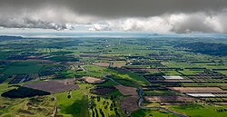 Rangitaiki plains | |
 | |
| Coordinates: 38°52′37″S 176°21′54″E / 38.877°S 176.365°ECoordinates: 38°52′37″S 176°21′54″E / 38.877°S 176.365°E | |
| Country | New Zealand |
| Region | Bay of Plenty |
| Territorial authority | Taupo District |
| Ward | Taupō-Kaingaroa |
| Population (2018) | |
| • Total | 132 |
| Postcode(s) | 3379 |

Rangitaiki is a rural community in the Taupo District and Bay Of Plenty Region of New Zealand's North Island, located near the source of Rangitaiki River. State Highway 5 runs through it.
It is an area of "frost flats" at the southern end of the Kaingaroa Plains, in the North Island Volcanic Plateau. European explorer and botanist John Bidwill visited the plain in 1839 and author Katherine Mansfield described the unique landscape in The Woman at the Store.[1]
The area experiences temperature similar to Central Otago in the winter months.[1] It experiences scrub fires in the summer.[2]
The settlement includes a school and country tavern.[2]
Demographics[]
| Year | Pop. | ±% p.a. |
|---|---|---|
| 2006 | 162 | — |
| 2013 | 135 | −2.57% |
| 2018 | 132 | −0.45% |
| Source: [3] | ||
The statistical area of Rangataiki, which at 996 square kilometres is much larger than the community, had a population of 132 at the 2018 New Zealand census, a decrease of 3 people (-2.2%) since the 2013 census, and a decrease of 30 people (-18.5%) since the 2006 census. There were 60 households. There were 72 males and 60 females, giving a sex ratio of 1.2 males per female. The median age was 30.8 years (compared with 37.4 years nationally), with 27 people (20.5%) aged under 15 years, 39 (29.5%) aged 15 to 29, 66 (50.0%) aged 30 to 64, and 6 (4.5%) aged 65 or older.
Ethnicities were 86.4% European/Pākehā, 18.2% Māori, 2.3% Pacific peoples, 9.1% Asian, and 2.3% other ethnicities (totals add to more than 100% since people could identify with multiple ethnicities).
The proportion of people born overseas was 11.4%, compared with 27.1% nationally.
Although some people objected to giving their religion, 68.2% had no religion, 25.0% were Christian and 2.3% had other religions.
Of those at least 15 years old, 15 (14.3%) people had a bachelor or higher degree, and 15 (14.3%) people had no formal qualifications. The median income was $44,700, compared with $31,800 nationally. The employment status of those at least 15 was that 63 (60.0%) people were employed full-time, 24 (22.9%) were part-time, and 0 (0.0%) were unemployed.[3]
Education[]
Rangitaiki School is a co-educational state primary school,[4] with a roll of 7 as of November 2021.[5][6] Its roll is one of the smallest in New Zealand.[7]
References[]
- ^ a b Smale, Mark (May 2007). "The frost flats of Rangitaiki". New Zealand Geographic. nzgeo.com.
- ^ a b Olley, Samantha (17 February 2019). "Helicopters helping fight fire at Rangitaiki, near State Highway 5". New Zealand Media and Entertainment. Rotorua Daily Post.
- ^ a b "Statistical area 1 dataset for 2018 Census". Statistics New Zealand. March 2020. Rangataiki (189800). 2018 Census place summary: Rangataiki
- ^ "Ministry of Education School Profile". educationcounts.govt.nz. Ministry of Education.
- ^ "New Zealand Schools Directory". New Zealand Ministry of Education. Retrieved 22 December 2021.
- ^ "Education Review Office Report". ero.govt.nz. Education Review Office.
- ^ Steven, Robert (10 November 2017). "Here's a tiny school with a big heart". Stuff.
- Taupo District
- Populated places in the Bay of Plenty Region