Rapidan Passenger Depot
Rapidan Passenger Depot | |
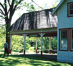
 The former Rapidan Passenger Depot in March 2013 | |
 | |
| Location | Rapidan, VA |
|---|---|
| Built | 1876 |
| Part of | Rapidan Historic District (ID87000723[1]) |
| Added to NRHP | May 8, 1987[2] |

The Rapidan Passenger Depot is located at the junction of VA 614, VA 615, and VA 673 in Rapidan, Virginia, United States.
History[]
In January 1848 three petitions were submitted to the Virginia General Assembly from businessmen in Culpeper County for incorporation of an "Orange and Alexandria Railroad Company". In March 1848 the Virginia General Assembly chartered the Orange and Alexandria Railroad Company. Its charter specified that it was to run from Gordonsville through Culpeper Court House to Alexandria.
The town in which the station lies began in the small milling community known as Waugh's Ford. With the coming of the Orange and Alexandria Railroad in 1854, the settlement was renamed Rapid Ann Station, reflecting the customary name of the river (a fast-moving stream named for Princess Ann).
In January 1854, the railroad reached the Rapidan River and a station was established. A post office was opened at "Rapid Ann Station". In April 1863, W.H.F. Lee's Confederate Cavalry burnt the Rapidan River Bridge. In September 1864, the federal cavalry burnt facilities at Mitchell and Rapidan Stations. In 1876, the Charlottesville & Rapidan RR was incorporated to construct a direct line between Orange and Charlottesville. The line was eventually merged into the Southern Railway and today serves as Norfolk Southern's mainline between the two cities. The original line between Orange and Gordonsville was leased to the Chesapeake & Ohio Railroad. The current Passenger Depot was constructed. In 1880, the Charlottesville and Rapidan Railroad was opened (Gordonsville by-pass). In 1886, the village and the station was renamed Rapidan. Today the station is part of the Rapidan Historic District.
References[]
External links[]
- Image of station
- Orange and Alexandria railroad stations
- Existing railroad stations in Culpeper County, Virginia
Coordinates: 38°18′47.8″N 78°3′55.1″W / 38.313278°N 78.065306°W

- Former railway stations in Virginia
- Railway stations in the United States opened in 1854
- Stations along Chesapeake and Ohio Railway lines
- Stations along Southern Railway lines in the United States
- Buildings and structures in Culpeper County, Virginia
- Transportation in Culpeper County, Virginia
- Historic district contributing properties in Virginia
- National Register of Historic Places in Culpeper County, Virginia
- 1854 establishments in Virginia