Rathbeale, Swords
Rathbeale
Ráth Béil[1] | |
|---|---|
Neighbourhood of Swords | |
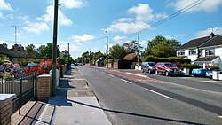 Rathbeale Road, looking northwest | |
 Rathbeale Location in Dublin area | |
| Coordinates: 53°27′44″N 6°13′48″W / 53.4622°N 6.2301°WCoordinates: 53°27′44″N 6°13′48″W / 53.4622°N 6.2301°W | |
| Country | Ireland |
| Province | Leinster |
| Region | Dublin |
| County | Fingal |
| Town | Swords |
| Government | |
| • Dáil Éireann | Dublin Fingal |
| • EU Parliament | Dublin |
| Time zone | UTC+0 (WET) |
| • Summer (DST) | UTC-1 (IST (WEST)) |
| Area code(s) | +353 (0)1 |
| Irish Grid Reference | O 174 473 |

Rathbeale is a neighbourhood in the town of Swords in Ireland. It developed in west Swords along the Rathbeale Road (R125), which runs from Swords to the townland of Rathbeal. It has been designed around the Rathbeale Road, which has shops, including two supermarkets, with housing estates on either side of the road.
Layout[]
Rathbeale is located west of the centre of Swords, along the Rathbeale Road. It is on the northside of the Ward River, between the areas of Applewood and Brackenstown. The Rathbeale Road runs through the centre of Rathbeale and there are housing estates on either side of the road.
Housing estates and streets in the Rathbeale area are:
- Rathbeale (Road, Court, Crescent, Rise, Grove)
- Saint Columbas (Rise, Heights)
- Brackenstown Avenue
- Oakwood Avenue
- Windmill (Avenue, Rise)
- Glasmore Park
- Elmwood (Drive, Park, Road)
- Abbeylea (Avenue, Close, Drive, Green)
- Daleview Road
- Saint Andrews Park
- Pine Grove (Park, Road)
- Mooretown (Avenue, Grove, Park, Road)
- Watery Lane
- Jugback Lane
- Collis Court
- Commons West
- Castlefarm
- Broadmeadows
Public Transport[]
The Rathbeale Road is served by Dublin Bus Routes 41, 41b, 41x, 41n and the private Urbus service.[2]
Dublin Bus route 41 operates approximately every 20 minutes from Swords Manor to Dublin City Centre (Lwr Abbey Street) through Rathbeale, Swords Village, Dublin Airport, Santry and Drumcondra. [3] Route 41b operates an infrequent service from Rolestown to Dublin City Centre (Lwr Abbey Street) through Rathbeale and Swords Village.[4] At peak times route 41x operates a service to UCD Belfield via Dublin City Centre.[5]
The Urbus service operates approximately every 90 minutes from Applewood to Castleknock via Rathbeale, Swords Village, Dublin Airport and Blanchardstown.[6]
On Friday and Saturday nights the Dublin Bus 41n Nitelink service operates from Dublin City Centre (Westmoreland Street) to Swords Manor via Dublin Airport, Swords Village and Rathbeale.[7]
Shops[]
Shops on the Rathbeale Road include supermarkets, a department store, a pharmacy, a newsagency and a florist. The public library is also on the Rathbeale Road.[8]
References[]
- ^ Placenames Database of Ireland
- ^ Transport for Ireland Public Transport Information
- ^ Dublin Bus 41 Timetable
- ^ Dublin Bus 41b Timetable
- ^ Dublic Bus 41x Timetable
- ^ Urbus Timetable
- ^ Nitelink 41n Timetable Archived 2012-10-20 at the Wayback Machine
- ^ Swords Library
- Neighbourhoods in Swords, Dublin