Raudeberg
Raudeberg | |
|---|---|
Village | |
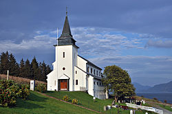 View of the local church | |
 Raudeberg Location in Vestland | |
| Coordinates: 61°59′06″N 5°08′16″E / 61.9850°N 5.1379°ECoordinates: 61°59′06″N 5°08′16″E / 61.9850°N 5.1379°E | |
| Country | Norway |
| Region | Western Norway |
| County | Vestland |
| District | Nordfjord |
| Municipality | Kinn Municipality |
| Area | |
| • Total | 0.67 km2 (0.26 sq mi) |
| Elevation | 4 m (13 ft) |
| Population (2018)[1] | |
| • Total | 656 |
| • Density | 979/km2 (2,540/sq mi) |
| Time zone | UTC+01:00 (CET) |
| • Summer (DST) | UTC+02:00 (CEST) |
| Post Code | 6710 Raudeberg |


Raudeberg is a village in Kinn Municipality in Vestland county, Norway. It is located on the east side of the island of Vågsøy. The villages of Refvika, Vedvika, and Langeneset are located a few kilometers to the north, and the town of Måløy is about 6 kilometres (3.7 mi) to the south. The island of Silda is located about 2 kilometres (1.2 mi) offshore to the northeast of the village of Raudeberg.[3] Nord-Vågsøy Church is located on the eastern edge of the village, right along the coast.
Raudeberg (historically spelled Rødberg) was the administrative centre of the former municipality of Nord-Vågsøy, which existed from 1910 until 1964. Today, it is the second largest settlement in the municipality, after the town of Måløy. The 0.67-square-kilometre (170-acre) village has a population (2018) of 656 and a population density of 979 inhabitants per square kilometre (2,540/sq mi).[1]
References[]
- ^ a b c Statistisk sentralbyrå (1 January 2018). "Urban settlements. Population and area, by municipality".
- ^ "Raudeberg, Vågsøy (Sogn og Fjordane)". yr.no. Retrieved 2019-10-12.
- ^ Store norske leksikon. "Raudeberg" (in Norwegian). Retrieved 2010-07-21.
This Vestland location article is a stub. You can help Wikipedia by . |
- Villages in Vestland
- Kinn
- Vestland geography stubs