Red Cones
| Red Cones | |
|---|---|
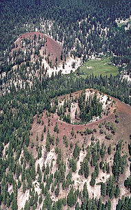 Close aerial view of the Red Cones toward the east-northeast. During eruption of both cones, lava poured through the breaches and spilled to the left. | |
| Highest point | |
| Elevation | 8,960 ft (2,730 m)[1] |
| Coordinates | 37°35′19″N 119°03′28″W / 37.58861°N 119.05778°WCoordinates: 37°35′19″N 119°03′28″W / 37.58861°N 119.05778°W[1] |
| Geography | |
| Location | Madera County, California, United States |
| Geology | |
| Age of rock | 8500 years |
| Mountain type | Cinder cone |
| Last eruption | 5000 years ago |

The Red Cones are a pair of cinder cones near Devils Postpile National Monument, in eastern Madera County of central California. They are within the eastern Sierra Nevada and Inyo National Forest.
Volcanic geology[]
The Red Cones last erupted approximately 5000 years ago,[2] with both cinder eruption (forming the cones), and a basalt flow from the southern cone, which flowed approximately 1.5 kilometers (0.9 mi) towards the upper Middle Fork of the San Joaquin River.[3]
The Red Cones are at the southern end of the Mono-Inyo Craters, the magma for the Red Cones shares its origin with the other Mono-Inyo craters.
See also[]
- Long Valley caldera
- Panum Crater
References[]
- ^ a b "Red Cones". Geographic Names Information System. United States Geological Survey.
- ^ "Future Eruptions in California's Long Valley Area—What's Likely?" (PDF). USGS.
- ^ "Red Cones, Long Valley area, California". Long Valley Observatory. USGS. Archived from the original on 2009-05-07.
Categories:
- Cinder cones of the United States
- Volcanoes of Madera County, California
- Inyo National Forest
- Landforms of the Sierra Nevada (United States)
- Volcanoes of California