Reilingen
show This article may be expanded with text translated from the corresponding article in German. (February 2009) Click [show] for important translation instructions. |
Reilingen | |
|---|---|
 Catholic church | |
 Coat of arms | |
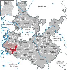
show Location of Reilingen within Rhein-Neckar-Kreis district | |
 Reilingen | |
| Coordinates: 49°17′41″N 08°34′09″E / 49.29472°N 8.56917°ECoordinates: 49°17′41″N 08°34′09″E / 49.29472°N 8.56917°E | |
| Country | Germany |
| State | Baden-Württemberg |
| Admin. region | Karlsruhe |
| District | Rhein-Neckar-Kreis |
| Government | |
| • Mayor | Stefan Weisbrod |
| Area | |
| • Total | 16.35 km2 (6.31 sq mi) |
| Elevation | 102 m (335 ft) |
| Population (2020-12-31)[1] | |
| • Total | 7,824 |
| • Density | 480/km2 (1,200/sq mi) |
| Time zone | UTC+01:00 (CET) |
| • Summer (DST) | UTC+02:00 (CEST) |
| Postal codes | 68799 |
| Dialling codes | 06205 |
| Vehicle registration | HD |
| Website | www.reilingen.de |


![]() Reilingen (help·info) is a municipality in the district of Rhein-Neckar in Baden-Württemberg, Germany. It is located on Bertha Benz Memorial Route.
Reilingen (help·info) is a municipality in the district of Rhein-Neckar in Baden-Württemberg, Germany. It is located on Bertha Benz Memorial Route.
References[]
- ^ "Bevölkerung nach Nationalität und Geschlecht am 31. Dezember 2020". Statistisches Landesamt Baden-Württemberg (in German). June 2021.
| show Towns and municipalities in Rhein-Neckar (district) |
|---|
| Authority control |
|---|
This Rhein-Neckar-Kreis location article is a stub. You can help Wikipedia by . |
Categories:
- Municipalities in Baden-Württemberg
- Rhein-Neckar-Kreis
- Baden
- Karlsruhe region geography stubs