Remungol
Remungol
Remengol | |
|---|---|
Part of Évellys | |
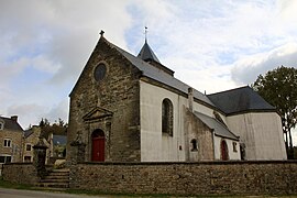 The church of Sainte-Julitte, in Remungol | |
 Coat of arms | |
show Location of Remungol | |
 Remungol | |
| Coordinates: 47°56′05″N 2°53′52″W / 47.9347°N 2.8978°WCoordinates: 47°56′05″N 2°53′52″W / 47.9347°N 2.8978°W | |
| Country | France |
| Region | Brittany |
| Department | Morbihan |
| Arrondissement | Pontivy |
| Canton | Grand-Champ |
| Commune | Évellys |
| Area 1 | 26.93 km2 (10.40 sq mi) |
| Population (2017)[1] | 978 |
| • Density | 36/km2 (94/sq mi) |
| Time zone | UTC+01:00 (CET) |
| • Summer (DST) | UTC+02:00 (CEST) |
| Postal code | 56500 |
| Elevation | 42–125 m (138–410 ft) |
| 1 French Land Register data, which excludes lakes, ponds, glaciers > 1 km2 (0.386 sq mi or 247 acres) and river estuaries. | |


Remungol (Breton: Remengol) is a former commune in the Morbihan department of Brittany in north-western France.
History[]
On 1 January 2016, Moustoir-Remungol, Naizin and Remungol merged becoming one commune called Évellys.
Geography[]
The Ével flows southwestward through the northern part of the commune, then forms its south-western border.
Demographics[]
Inhabitants of Remungol are called in French Remungolais.
See also[]
References[]
External links[]
| Wikimedia Commons has media related to Remungol. |
- Base Mérimée: Search for heritage in the commune, Ministère français de la Culture. (in French)
This Morbihan geographical article is a stub. You can help Wikipedia by . |
Categories:
- Former communes of Morbihan
- Morbihan geography stubs