Reuth bei Erbendorf
show This article may be expanded with text translated from the corresponding article in German. (August 2018) Click [show] for important translation instructions. |
Reuth bei Erbendorf | |
|---|---|
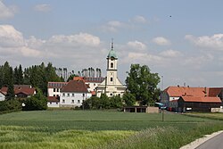 Reuth bei Erbendorf | |
 Coat of arms | |
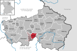
show Location of Reuth bei Erbendorf within Tirschenreuth district | |
 Reuth bei Erbendorf | |
| Coordinates: 49°51′N 12°7′E / 49.850°N 12.117°ECoordinates: 49°51′N 12°7′E / 49.850°N 12.117°E | |
| Country | Germany |
| State | Bavaria |
| Admin. region | Oberpfalz |
| District | Tirschenreuth |
| Municipal assoc. | Krummennaab |
| Subdivisions | 15 Ortsteile |
| Government | |
| • Mayor (2020–26) | Werner Prucker[1] (FW) |
| Area | |
| • Total | 16.91 km2 (6.53 sq mi) |
| Elevation | 476 m (1,562 ft) |
| Population (2020-12-31)[2] | |
| • Total | 1,125 |
| • Density | 67/km2 (170/sq mi) |
| Time zone | UTC+01:00 (CET) |
| • Summer (DST) | UTC+02:00 (CEST) |
| Postal codes | 92717 |
| Dialling codes | 09681, 09682, 09683 |
| Vehicle registration | TIR |
| Website | https://www.reuth-b-erb.de/ |


Reuth bei Erbendorf is a municipality in the district of Tirschenreuth in Bavaria, Germany.
References[]
- ^ Liste der ersten Bürgermeister/Oberbürgermeister in kreisangehörigen Gemeinden, Bayerisches Landesamt für Statistik, 15 July 2021.
- ^ "Tabellenblatt "Daten 2", Statistischer Bericht A1200C 202041 Einwohnerzahlen der Gemeinden, Kreise und Regierungsbezirke". Bayerisches Landesamt für Statistik (in German). June 2021.
| show Towns and municipalities in Tirschenreuth (district) |
|---|
| Authority control |
|---|
This Tirschenreuth district location article is a stub. You can help Wikipedia by . |
Categories:
- Municipalities in Bavaria
- Tirschenreuth (district)
- Upper Palatinate geography stubs