Richat Structure
| Richat Structure | |
|---|---|
| Tagense[1] | |
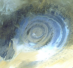
 Inner ring of the Richat Structure | |
 | |
| Location | |

• Brown: bedrock
• Yellow/white: sand
• Green: vegetation
• Blue: salty sediments

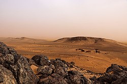
The Richat Structure, also called Guelb er Richât (Arabic قلب الريشات Qalb ar-Rīšāt), is a prominent circular feature in the Sahara's Adrar Plateau, near Ouadane, west–central Mauritania, Northwest Africa. In the local dialect, Richat means feather and it also is known locally in Arabic as tagense. Tagense refers to the circular opening of the leather pouch used to draw water from local wells.[1]
It is an eroded geological dome, 40 kilometres (25 mi) in diameter, exposing sedimentary rock in layers which appear as concentric rings. Igneous rock is exposed inside and there are spectacular rhyolites and gabbros which have undergone hydrothermal alteration, and a central megabreccia. The structure is also the location of exceptional accumulations of Acheulean archaeological artifacts.
Description[]
The Richat Structure is a deeply eroded, slightly elliptical dome with a diameter of 40 kilometres (25 mi). The sedimentary rock exposed in this dome ranges in age from Late Proterozoic within the center of the dome to Ordovician sandstone around its edges. The sedimentary rocks composing this structure dip outward at 10–20°. Differential erosion of resistant layers of quartzite has created high-relief circular cuestas. Its center consists of a siliceous breccia covering an area that is at least 30 kilometres (19 mi) in diameter.[2][3][4]
Exposed within the interior of the Richat Structure are a variety of intrusive and extrusive igneous rocks. They include rhyolitic volcanic rocks, gabbros, carbonatites and kimberlites. The rhyolitic rocks consist of lava flows and hydrothermally altered tuffaceous rocks that are part of two distinct eruptive centers, which are interpreted to be the eroded remains of two maars. According to field mapping and aeromagnetic data, the gabbroic rocks form two concentric ring dikes. The inner ring dike is about 20 m in width and lies about 3 km from the center of the Richat Structure. The outer ring dike is about 50 m in width and lies about 7 to 8 km from the center of this structure. Thirty-two carbonatite dikes and sills have been mapped within the Richat Structure. The dikes are generally about 300 m long and typically 1 to 4 m wide. They consist of massive carbonatites that are mostly devoid of vesicles. The carbonatite rocks have been dated as having cooled between 94 and 104 million years ago. A kimberlitic plug and several sills have been found within the northern part of the Richat Structure. The kimberlite plug has been dated to around 99 million years old. These intrusive igneous rocks are interpreted as indicating the presence of a large alkaline igneous intrusion that currently underlies the Richat Structure and created it by uplifting the overlying rock.[2][3][5][6]
Spectacular hydrothermal features are a part of the Richat Structure. They include the extensive hydrothermal alteration of rhyolites and gabbros and a central megabreccia created by hydrothermal dissolution and collapse. The siliceous megabreccia is at least 40 m thick in its center to only a few meters thick along its edges. The breccia consists of fragments of white to dark gray cherty material, quartz-rich sandstone, diagenetic cherty nodules, and stromatolitic limestone and is intensively silicified. The hydrothermal alteration, which created this breccia, has been dated to have occurred about 98.2 ± 2.6 million years ago using the 40Ar/39Ar method.[2][3][6]
Interpretation[]
The Richat Structure is regarded by geologists as a highly symmetrical and deeply eroded geologic dome. It was first described in the 1930s to 1940s, as Richât Crater or Richât buttonhole (boutonnière du Richât). Richard-Molard (1948) considered it to be the result of a laccolithic thrust.[7] A geological expedition to Mauritania led by Théodore Monod in 1952 recorded four "crateriform or circular irregularities" (accidents cratériformes ou circulaires) in the area, Er Richât, Aouelloul (south of Chinguetti), Temimichat-Ghallaman and Tenoumer.[8] Origin of Er Richât as an impact structure (as is clearly the case with the other three) was briefly considered, but closer study in the 1950s to 1960s suggested that it was formed by terrestrial processes. After extensive field and laboratory studies in the 1960s, no credible evidence has been found for shock metamorphism or any type of deformation indicative of a hypervelocity extraterrestrial impact.[9] While coesite, an indicator of shock metamorphism, had initially been reported as being present in rock samples collected from the Richat Structure, further analysis of rock samples concluded that barite had been misidentified as coesite.[10]
Work on dating the structure was done in the 1990s.[11] Renewed study of the formation of the structure by Matton et al. (2005) and Matton (2008) confirmed the conclusion that it is not an impact structure. The circular distribution of ridges and valleys is explained as the formation of cuestas by the differential erosion of alternating hard and soft rock layers uplifted as a dome by an underlying alkaline igneous complex of Cretaceous age.[12]
A 2011 multianalytical study on the Richat megabreccias concluded that carbonates within the silica-rich megabreccias were created by low-temperature hydrothermal waters, and that the structure requires special protection and further investigation of its origin.[13]
Archaeology[]
The Richat Structure is the location of exceptional accumulations of Acheulean artifacts.[14][15] These Acheulean archaeological sites are located along wadis that occupy outermost annular depression of this structure. Pre-Acheulean stone tools also have been found in the same areas. These sites are associated with rubbly, outcrops of quartzite that provided the raw material needed for the manufacture of these artifacts. The most important Acheulean sites and their associated outcrops are found along the north-west of the outer ring, from which Wadi Akerdil heads east and Wadi Bamouere to the west. Sparse and widely scattered Neolithic spear points and other artifacts have also been found. However, since these sites were first discovered by Theodore Monod in 1974,[14] mapping of artifacts within the area of the Richat Structure have found them to be generally absent in its innermost depressions. So far, neither recognizable midden deposits nor manmade structures have been recognized and reported from the Richat Structure. This is interpreted as indicating that area of the Richat Structure was used for only short-term hunting and stone tool manufacturing. The local, apparent wealth of surface artifacts is the result of the concentration and mixing by deflation over multiple glacial-interglacial cycles.[15][16]
Artifacts are found, typically redeposited, deflated, or both, in Late Pleistocene to early Holocene gravelly mud, muddy gravel, clayey sand, and silty sand. These sediments are often cemented into either concretionary masses or beds by calcrete. Ridges typically consist of deeply weathered bedrock representing truncated Cenozoic paleosols that formed under tropical environments. The Pleistocene to Middle Holocene sediments occur along wadis as thin, meter- to less than meter-thick accumulations in the interior annular depressions to 3–4 meters (9.8–13.1 ft) thick accumulations along the wadis in the outermost annular depression of the Richat Structure. The gravelly deposits consist of mixture of slope scree, debris flow, and fluviatile or even torrential flow deposits. The finer grained, sandy deposits consist of eolian and playa lake deposits. The latter contain well-preserved, freshwater fossils. Numerous concordant radiocarbon dates indicate that the bulk of these sediments accumulated between 15,000 and 8,000 BP during the African humid period. These deposits lie directly upon deeply eroded and weathered bedrock.[16]
References[]
- ^ Jump up to: a b Richard-Molard, J. (1952). "La pseudo-boutonniers du Richat". Gouvernement General de l'Afrique Occidentale Francaise Bulletin de la Direction des Mines. 15 (2): 391–401.
- ^ Jump up to: a b c Matton, G. (2008). "The Cretaceous Richat Complex (Mauritania); a peri-Atlantic alkaline" (PDF). Chicoutimi, Quebec, Canada: Université du Québec à Chicoutimi.
- ^ Jump up to: a b c Matton, Guillaume; Jébrak, Michel; Lee, James K.W. (2005). "Resolving the Richat enigma: Doming and hydrothermal karstification above an alkaline complex" (PDF). Geology. 33 (8): 665–68. doi:10.1130/G21542AR.1.
- ^ Woolley, A. R. (2001) Alkaline Rocks and Carbonatites of the World, Part 3: Africa. London, United Kingdom, The Geological Society of London. ISBN 978-0-412-61410-1
- ^ Netto, A.M.; Fabre, J.; Poupeau, G.; Champemmois, M. (1992). "Datations par traces de fissions de la structure circulaire des Richats". Comptes Rendus de l'Académie des Sciences de Paris. 314: 1179–1186.
- ^ Jump up to: a b Matton, Guillaume; Jébrak, Michel (2014). "The "eye of Africa" (Richat dome, Mauritania): An isolated Cretaceous alkaline–hydrothermal complex". Journal of African Earth Sciences. 97: 109–124. Bibcode:2014JAfES..97..109M. doi:10.1016/j.jafrearsci.2014.04.006.
- ^ Richard-Molard, Jacques. "La boutonnière du Richât en Adrar Mauritanien". Comptes Rendus de l'Académie des Sciences. 227: 142.
- ^ Notes africaines, Issues 109–124 (1966), p. 32.
- ^ Dietz, Robert S.; Fudali, Robert; Cassidy, William (1969). "Richat and Semsiyat Domes (Mauritania): Not Astroblemes". Geological Society of America Bulletin. 80 (7): 1367. Bibcode:1969GSAB...80.1367D. doi:10.1130/0016-7606(1969)80[1367:RASDMN]2.0.CO;2.
- ^ Fudali, R. F. (10 October 1969). "Coesite from the Richat Dome, Mauritania: A Misidentification". Science. 166 (3902): 228–230. Bibcode:1969Sci...166..228F. doi:10.1126/science.166.3902.228. PMID 17731489. S2CID 37249316.
- ^ Netto, A.M.; Fabre, J.; Poupeau, G.; Champemmois, M. (1992). "Datations par traces de fissions de la structure circulaire des Richats". Comptes Rendus de l'Académie des Sciences de Paris. 314: 1179–86.
Poupeau, G.; Fabre, J.; Labrin, E.; Azdimoussa, A.; Netto, A. M.; Monod, T. (1996). "Nouvelles datations par traces de fission de la structure circulaire des Richat (Mauritanie)". Mémoires du Service Géologique de l'Algérie. 8: 231–36. - ^ "The breccia core is genetically related to plutonic activity, since doming and the production of hydrothermal fluids were instrumental in creating a favorable setting for dissolution. The resulting fluids were also responsible for subsequent silicification and hydrothermal infilling. To the best of our knowledge, karst collapse phenomena at the summit of an alkaline complex are unique, but may be more frequent than previously believed." (Matton 2005)
- ^ Martinez-Frias, J.; Rull, F.; Martín-Redondo, M. P.; Delgado, A.; Fernández-Sampedro, M. T.; García-Talavera, F.; López-Vera, F.; Menor Salván, C. (2011). "Multianalytical characterization of silica-rich megabreccias from the proposed natural area of Richat (Sahara desert, Mauritania)". Research Journal of Chemistry and Environment. 15 (3): 49–54.
- ^ Jump up to: a b Monod, T. (1975). "Trois gisements à galets aménagés dans l'Adrar mauritanien (Sahara occidental)". Provence Historique. 99: 87–97.
- ^ Jump up to: a b Sao, Ousmane; Giresse, Pierre; de Lumley, Henry; Faure, Olivier; Perrenoud, Christian; Saos, Thibaud; Rachid, Mouamar Ould; Touré, Ousmane Cherif (2008). "Les environnements sédimentaires des gisements pré-acheuléens et acheuléens des wadis Akerdil et Bamouéré (Guelb er-Richât, Adrar, Mauritanie), une première approche". L'Anthropologie. 112 (1): 1–14. doi:10.1016/j.anthro.2008.01.001.
- ^ Jump up to: a b Giresse, Pierre; Sao, Ousmane; de Lumley, Henry (2012). "Étude paléoenvironnementale des sédiments quaternaires du Guelb er Richât (Adrar de Mauritanie) en regard des sites voisins ou associés du Paléolithique inférieur. Discussion et perspectives". L'Anthropologie. 116 (1): 12–38. doi:10.1016/j.anthro.2011.12.001.
External links[]
| Wikimedia Commons has media related to Richat Structure. |
- Anonymous (nd) Richat Structure, Mauritania NASA Earth Observatory
- Anonymous (nd) Earth’s Bulls-Eye, the Eye of Africa, Landmark for Astronauts. Love These Pics
- Nemiroff, R., and J. Bonnell (2002) Earth's Richat Structure, Astronomy Picture of the Day, October 28, 2002. Astronomy Picture of the Day, Michigan Technological University, Houghton, Michigan.
- Découverte - L'énigme de Richat (French), a video documentary from Radio Canada.
| hide Authority control | |
|---|---|
| General |
|
| Other | |

- Adrar Region
- Geology of Mauritania
- Geography of Mauritania
- Regional geology
- Structural geology
- Tiris Zemmour Region
- Geologic domes
- Sahara