Riera de Merlès
| Merlès | |
|---|---|
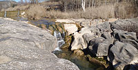 The riera de Merlès in winter, passing through the village of Santa Maria de Merlès | |
| Location | |
| Country | Spain |
| Physical characteristics | |
| Source | |
| • location | Rasos de Tubau in Sant Jaume de Frontanyà and |
| • elevation | 1,485 m (4,872 ft)[1] |
| Mouth | |
• location | Llobregat River in Puig-reig |
• coordinates | 41°55′36.01″N 1°52′55.51″E / 41.9266694°N 1.8820861°ECoordinates: 41°55′36.01″N 1°52′55.51″E / 41.9266694°N 1.8820861°E |
• elevation | 345 m (1,132 ft)[1] |
| Basin size | 173 km2 (67 sq mi)[2] |
| Discharge | |
| • average | 0.90 m3/s (32 cu ft/s)[2] |
| Basin features | |
| River system | Llobregat |

The Riera de Merlès is a small river that passes through the comarques of Osona, Bages, and Berguedà. It is formed by the confluence of several small mountain creeks and torrents that descend the , in the municipalities of Sant Jaume de Frontanyà and Les Llosses.[2]
Historically, the Merlès marked several administrative frontiers. These include the ancient counties of Berga and Osona, the dioceses of Solsona and Vic, and the modern comarques of Berguedà and Lluçanès.[2]
References[]
This article about a location in Catalonia is a stub. You can help Wikipedia by . |
Categories:
- Rivers of Spain
- Rivers of Catalonia
- Catalonia geography stubs
- Spain river stubs